
Yacolt Burn State Forest
Attention: Alerts and Closures
Recreation alert: Jones Creek ORV TH will be closed to mid-week parking due to construction activity until late April. Motorized trails are currently closed for the season from December 1 through April 30.
Recreation alert: The L-1500 is closed for through access, from Four Corners to the L-1520 gate, due to logging activities until further notice. The L-1200, road to Grouse Vista Trailhead, is also closed to through access due to logging activities until further notice. Once operations are completed this alert will be updated.
Recreation alert: The L-1070 road, Sixth Sense and Vista Ridge Trails are closed due to logging activities until further notice. Active log trucks on roadway. Once operations are completed this alert will be updated.
Recreation alert: Logging and road work activities will result in periodic closures and equipment on roadways along the L1500, L1530, L1560 and L1000 roads through April 2024.
Recreation alert: Motorized trails are closed for the season from December 1 through April 30.
Recreation alert: Forest roads are not maintained or plowed. Please be prepared for rapidly changing conditions while driving in the winter.
The 90,000-acre Yacolt Burn State Forest, and nearby areas to the north and east in Cowlitz, Clark, Skamania, and Klickitat counties, are working forests. The Washington State Department of Natural Resources (DNR) manages timber production, biomass byproducts, communication tower leases, and other activities in the forest to help fund local county services and the construction of public K-12 schools throughout Washington.
In addition to earning income for state trust land beneficiaries, the undeveloped working forests in this area provide habitat for native plants and animals, water retention and water quality benefits, and diverse recreation opportunities that help support local economies.
History
The forest is named for the dozens of wildfires that ravaged Clark, Cowlitz and Skamania counties in southwest Washington during September 1902. With no organized system for fighting wildfires, the fires spread across nearly 239,000 acres and caused 38 deaths and widespread property losses. An extended period of hot, dry weather; high wind; an over-accumulation of timber harvest slash; and human carelessness are among the frequently cited causes of these fires. In response, the Washington Legislature established a state fire warden the following year. In 1908, private landowners formed the Washington Fire Protection Association and funded a system of fire wardens and a program of fire prevention on private lands.
Recreation
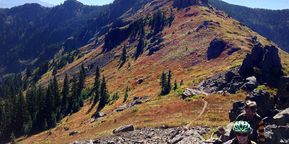
The array of recreation activities in the Yacolt Burn State Forest include horseback riding, off-road vehicle riding, mountain biking, camping and hiking. The Yacolt Burn State Forest is open year-round for hiking, horseback riding, and mountain biking. Whether you're looking to ride off-road vehicles from the Jones Creek Trailhead, take a hike from the Grouse Vista Trailhead, mountain bike from the Larch Mountain Trailhead or camp at the equestrian-oriented Rock Creek Campground, Yacolt Burn State Forest has something for everyone.
Yacolt Burn State Forest Tips
- Camping stays are limited to 10 days within a 365-day period.
- Some campgrounds close seasonally for inclement weather. Check here before you make the drive.
- Don't ride ATVs or motorcycles in campgrounds.
- Off-road vehicles are allowed on open gravel forest roads.
- Dogs are allowed in Yacolt Burn if they are on a leash. Horseback riders may bring unleashed dogs if they are controlled by voice command.
- Be alert for other road users, ranging from heavy vehicles to bicycles, and check your speed accordingly
Target Shooting
The following areas in the Yacolt Burn State Forest are closed to target shooting:
- On the entirety of the L-1000 Road.
- On the L-1500 Road from four corners eastbound until the rock pit.
- On the entirety of the L-1400 Road.
- On the L-1200 Road, where it is signed "No Shooting."
- Anywhere that doesn't meet the WAC criteria.
Trail Maps
Visit our motorized system map, which includes Jones Creek and Hagen Creek and our non-motorized trail maps for the Yacolt Burn State Forest.
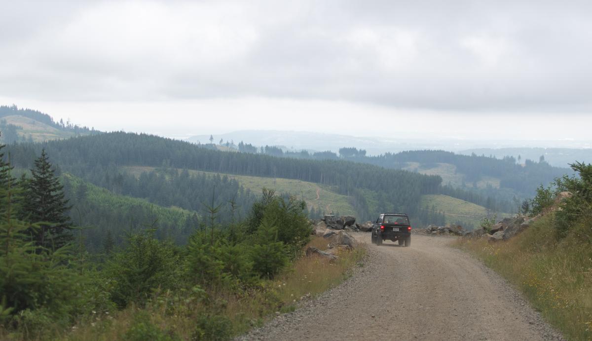
A 4x4 vehicle driving down L-1500 towards the Jones Creek ORV Trailhead in Yacolt Burn State Forest. Photo by Mitchell Emerson.
Other Tips for your visit
- Don’t forget your Discover Pass! Learn more about it at DiscoverPass.wa.gov
- Campsites are available first-come, first-served at no additional cost with the purchase of a Discover Pass.
- Enjoy a campfire in approved fire pits in designated campgrounds only. Always check for burn restrictions before lighting a campfire.
- Don't Move Firewood. Help protect Pacific Northwest forests by preventing the spread of invasive species. Firewood can carry insects and diseases that can threaten the health of our western forests. Please purchase firewood near your campsite. Find more information here.
Leave No Trace
Please follow the seven principles of Leave No Trace for your safety and the safety of our wildlife, please follow the seven principles of Leave No Trace. You can brush up on them here. Food and garbage that is left behind or improperly disposed of can attract wildlife and create potentially dangerous situations for visitors. Please pack out all food items and garbage. NEVER feed wildlife.
Recreation Sites
Yacolt Burn State Forest
Three Corner Rock Trailhead
Three Corner Rock Trailhead, in Yacolt Burn State Forest, provides access to a 9-mile trail and 2,650-foot elevation gain to views of Stebbins Creek Valley and Washougal River. This trail accesses the Pacific Crest Trail. View our trail map of the Three Corner Rock Trail. Download a parking map here.
Directions: From Washougal River Road, at the end of a country road, turn right at Y onto the W-2000 along the Washougal River for 3.3 miles. Trailhead on the left. Get directions.
Recreation alert: Three Corner Rock Trail is closed indefinitely due to forest management activities in the area. Updates will be posted as they occur.
Cold Creek Campground and Day-use Area
Cold Creek Campground has a day-use area and a campground. It provides access to 35 miles of the Yacolt Burn non-motorized trail system. Facilities include eight campsites, picnic tables, shelter, and a vault toilet. Accommodates RVs up to 25 feet. View our Cold Creek campground and day-use map.
Cold Creek Campground is open Thursday through Monday. The campground is closed Monday afternoon through Thursday morning. Campers are to register with hosts at Rock Creek Horse Camp.
Directions: Start five miles north of Vancouver at I-5 exit 9. Go east on Northeast 179th Street for 5.5 miles. Turn right on SR-503. Go 1.5 miles. Turn left on Northeast 159th Street. Go 3 miles. Turn right on Northeast 182 Avenue at Hockinson. Go one mile. Turn left on Northeast 139th Street at 2.5 miles, take a left “Y” onto Rawson Road. At 2 miles, the pavement ends, and the road turns into the L-1400 Road. Go 4 miles. Turn left on L-1000 Rd. Go 4 miles. Turn left on L-1300 Rd. Go .8 miles to the site. Get directions.
Note: The campground is closed for the season and expected to reopen May 2, 2024
Dougan Creek Campground
The large boulders, forested edges, and cascading 100-foot waterfalls of Dougan Creek are a treat for picnickers and campers who visit Yacolt Burn State Forest. The campground has seven campsites, five picnic tables, and a vault toilet. Accommodates RVs up to 16 feet. Download a parking map here and download the campground and day-use map here.
Directions: Exit SR-14 at Washougal; follow Washougal River Road for the entire 16.4-mile route to camp. At the end of a country road, bear left at Y. The site is on the left, approximately 1 mile from the fish hatchery. Get directions.
Recreation Note: Dougan Falls Campground is open April 15 through October 15, weather dependent
Dougan Creek Day-use Area
The large boulders, forested edges, and cascading 100-foot waterfalls of Dougan Creek are a treat for picnickers and campers who visit Yacolt Burn State Forest. The day-use area has picnic tables and a vault toilet. View a map of the area here.
Directions: Exit SR-14 at Washougal; follow Washougal River Road for the entire 16.4-mile route to camp. At the end of a country road, bear left at Y. The site is on the left, approximately 1 mile from the fish hatchery. Get directions.
Recreation alert: Dougan Falls Day-use area is very busy during the summer months. Visitors are advised to arrive early as parking is limited. Download a parking map here. Please respect our neighbors and do not trespass on private property. Always pack out your trash.
Rock Creek Campground
Located on nearly 20 acres of forested land in the Yacolt Burn State Forest, Rock Creek Campground is perfect for equestrian use. The campground includes campsites, picnic tables, shelter, and vault toilets. Accommodates RVs up to 27 feet. View our Rock Creek Campground map.
Directions: Continue north on L-1000 Rd from the entrance of Cold Creek Camp toward Dole Valley Road for .7 miles. The site entrance is on the right. Get directions.
Note: Camp host does not sell firewood nor Discover Passes. Please come prepared.
Recreation alert - Equestrian Users: The Yacolt Burn Trailhead is the primary access point for mountain bikers on weekends. The Sixth Sense Trail is a multi-use, two-way trail heavily used by mountain bikers in the downhill direction, particularly on weekends. When planning your weekend trail rides, please consider using alternative routes to access the Tarbell Trail. View the Yacolt Burn State Forest non-motorized trails map.
Grouse Vista Trailhead
Located in the Yacolt Burn State Forest, Grouse Vista offers access for hikers, mountain bikers, and horseback riders. No amenities at the parking lot. View our trail map.
Directions: Follow directions to Rock Creek Campground. Return to L-1200 Rd at Rock Creek entrance. Go 5.0 mi. S to trailhead parking. Get directions.
Jones Creek ORV Trailhead
Jones Creek ORV Trailhead is the premiere ORV trail in Southwest Washington. It has 14 miles of double-track motorcycle and all-terrain vehicle trails. This trailhead draws more than 15,000 visitors each year. Jones Creek Trailhead provides access to the ORV trails, including Deer Pen Trail, Mountain View Trail, and the Hagen Creek Trail System. Day use only. Vault toilet at the site. Jones Creek ATV, motorcycle, and 4x4 trails close seasonally from December 1 - April 30. View the Yacolt Burn motorized trail map and the trail map of the Jones Creek area trails. Closed seasonally from Dec. 1 - Apr. 30.
Recreation alert: Jackson Pass Trail is closed due to forest practice activities between the L-1500 to the L-1560.
Directions: Start in Camas at the junction with SR-14. Go north on SR 500 for 3.8 miles to Fern Prairie. Turn right on Northeast 19th Street and go .8 miles. Turn left on Northeast Reilly Road. Go 1.9 miles. Turn right on Northeast Ireland Road. Go .2 miles. Turn left on NE Lessard Road. At 3.7 miles, veer left onto the gravel road. Travel .3 miles to the trailhead. Get directions.
Hagen Creek Trail System
Opened in May 2015 as the first official 4x4 trail system in the Yacolt Burn State Forest, this roughly 6-mile loop trail system provides opportunities for primarily 4x4, as well as ATV driving. The trail system features a rock crawl. View a map of the Hagen Creek Trail System. To download to a mobile device, click here. Closed seasonally from Dec. 1 - Apr. 30.
Opened in May 2015 as the first official 4x4 trail system in the Yacolt Burn State Forest, this roughly 6-mile loop trail system provides opportunities for primarily 4x4, as well as ATV driving. The trail system features a rock crawl. View a map of the Hagen Creek Trail System. To download to a mobile device, click here. Closed seasonally from Dec. 1 - Apr. 30.
Directions: Start in Camas at the junction with SR-14. Go north on SR 500 for 3.8 miles to Fern Prairie. Turn right on Northeast 19th Street and go .8 miles. Turn left on Northeast Reilly Road. Get directions.
Larch Mountain Trailhead
Located in the Yacolt Burn State Forest, Larch Mountain Trailhead provides upper access to the Thrillium Trail and has 19 parking spots and a vault toilet. The Thrillium Trail is popular for mountain biking. View our trail map.
Directions: On I-5 south, take I-205 and exit 32 Padden Parkway. Turn left at the light. Stay straight for NE Ward Road; continue straight. Turn right on 139 Road, which becomes NE Rawson Road. Hang right to L-1400, which becomes L-1500. Larch Mountain Trailhead will be on the left. Get directions.
Tarbell Trailhead on Bells Mountain
With parts of this trail in existence for more than 100 years, Tarbell Trailhead was formerly used exclusively by equestrians and hikers. Now, mountain bikers and other non-motorized recreationists also the 35-mile system. Trailhead has picnic tables and a vault toilet. View our trail map.
Directions: At the entrance to Rock Creek from L-1000, continue north onto Dole Valley Road. Turn left onto the L-1100 road, and at the junction with the L-1210 road, turn right, and the trailhead is on your left. Get directions.
Yacolt Burn Trailhead
The Yacolt Burn Trailhead provides lower access to the Thrillium Trail, a premier mountain biking trail in the Yacolt Burn State Forest. The parking area has 37 parking spots. View our trail map.
The Yacolt Burn Trailhead provides lower access to the Thrillium Trail, a premier mountain biking trail in the Yacolt Burn State Forest. The parking area has 37 parking spots. View our trail map.
Directions: On I-5 south, take I-205 and exit 32 Padden Parkway. Turn left at the light. Stay straight for NE Ward Road. Continue straight. Turn right on 139 Street. Turn left on L-1050. Go straight till Yacolt Burn Trailhead. Get directions.
Surrounding Area
Bradley ORV Area
Located outside of Cathlamet, Bradley ORV Trailhead draws visitors from Washington and Oregon for its miles of motorized off-road-vehicle trails. Day use only. No camping. View our trail map of the Bradley ORV Trail.
Recreation alert: Several sections of the Bradley ORV trail are closed due to forest practice activities. Riders can use forest roads where the trail is closed to reconnect with the trail.
Directions: From Cathlamet, turn right onto Elochoman Valley Rd. Drive east for 3.6 miles. Turn right onto Beaver Creek Rd. Continue for 4.4 miles. Turn left onto Keyser Rd and drive 1.9 miles to the trailhead, which will be on the right. Get Directions. Get directions.
Butte Creek Day-Use Area
Butte Creek is a historically significant site in Pacific County that was part of the original Butte Creek Homestead of Marion and Sarah Ann Monohon. The area was renovated and reopened in 2019 and offered visitors a .8-mile loop trail, seven picnic sites with new tables and regraded roadways and paths. Get the map.
Directions: From Raymond, take Highway 101 North. Cross over Butte Creek. Parking for the day-use area will be on the right just past the Willapa Harbor Gun Club. Get directions.
North Siouxon Creek Trailhead
Recreation alert: The North Fork Siouxon Creek Trail, trail to Black Hole Falls, is closed for visitor safety due to forest practice activities taking place in the area. Anticipated re-opening is late June 2024. Information will be updated as it becomes available.
Mount Mitchell sits at about 3,960 feet elevation in the Siouxon Forest Block. North Siouxon Creek Trailhead and the Mitchell Peak Trailhead, in the southern part of the block, offer access to Mount Mitchell by a 13-mile trail. The trail offers views of the black hole waterfall. View our trail map.
Directions: From Chelatchie Prairie, head east on Healy Road, continue on FS 54 Road and make a second left after the bridge. Stay straight onto S-1000 Road. Turn right onto S2000. North Fork Siouxon Creek Trail South trailhead is on your right. Get directions.
Snag Lake Campground
Located north of Naselle, Snag Lake is a primitive campground situated on the way up to Radar Ridge. The campground has two RV sites and seven walk-in tent sites, fishing docks, and a restroom. Get the map.
Directions: Start at milepost 3 on SR-4. Go north on C-Line Road; take the left fork at Naselle Youth Camp entrance for 2.9 miles. Turn left on C-2600 Road (gravel, one lane) for .6 miles. Turn right on C-2620; the camp is at the end of the road. Get directions.
Tunerville Campground
This four-campsite campground, located northeast of Naselle in Pacific County, is highly valued by the recreating public for being an equestrian-oriented camp. Salmon Creek is nearby. The campground has horse corrals, vault toilet. Campsites can accommodate up to a 16-foot RV, though size may vary by site. Get the map.
Directions: Start from the junction of SR-401 and SR-4. Go east for 3.5 miles. Turn north onto Salmon Creek Road and go northeast 8.5 miles to the Tunerville recreation site. Get directions.
Western Lake Campground
Located north of Naselle, this five tent-only campsite lake is situated on the way up to Radar Ridge. There is a short trail that goes around the lake and a trail connecting to Snag Lake. Get the map.
Directions: Start at milepost 3 on SR-4. Go north on C-Line Road; take the left fork at Naselle Youth Camp entrance for 2.9 miles. Turn left on C-2600 Road for 0.9 miles. Turn right on C-2650 Road for .3 miles to the site. Get directions.
Winston Creek Campground
This fully forested and streamside campground offers visitors 11 campsites. It’s located within Winston Creek Forest Block that offers only dispersed recreation aside from the campground, and is very popular for elk hunting. Winston Creek Campground closes seasonally from mid-December through mid-May. Accommodates RVs up to 25 feet.
Directions: Start on Highway 12 southeast of Chehalis (between mileposts 82-83). Go south on Winston Creek Road for 3.6 miles. Turn left on Longbell Road for 1 mile. The site is on the right. Get directions.
Recreation alert: Winston Campground is under a reservation system and will begin to take 2023 reservations starting May 1. If you would like to reserve a site, please follow these instructions. You can refer to this campground map for more information on the available campsites.
Other recreation opportunities
Located near the Yacolt Burn State Forest, the Merrill Lake Natural Resources Conservation Area, and the Table Mountain Natural Resources Conservation Area also provide recreation opportunities. Use our statewide interactive recreation map to find recreation opportunities near you.
