
Little Pend Oreille State Forest
|
|
Attention: Alerts and Closures
Recreation alert: Campfires in approved campgrounds are allowed. No dispersed campfires.
The Little Pend Oreille forest and nearby state trust lands in Stevens and Pend Oreille counties are working forests managed by the Department of Natural Resources (DNR) to provide sustainable revenue in support of public services. Timber production, communication tower leases, and other activities help to fund specific beneficiaries, such as local services, prisons, universities, and the construction of public K-12 grade schools throughout Washington.
In addition to earning income, the undeveloped working lands in this area provide habitat for native plants and animals, water retention and quality benefits, and diverse recreation opportunities, which help to support local economies.
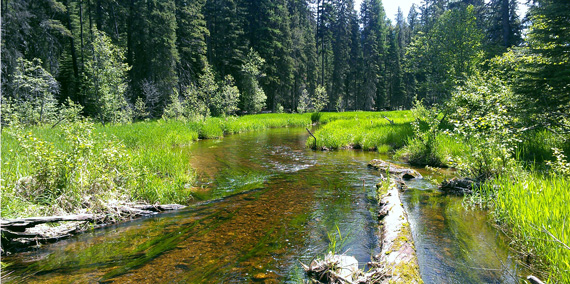
Recreation
Located in northeast Washington near Colville, the Little Oreille Forest block provides diverse recreational experiences, including camping, off-road-vehicle riding, fishing, mountain biking, and winter activities. Whether you're looking to fish and relax near Starvation Lake, or enjoy miles of forest off-road-vehicle riding from the Little Pend Oreille trail system, the Little Pend Oreille Forest block has something for the whole family. View a trail map of the Little Pend Oreille trail system.
Little Pend Oreille Forest Tips
- Limit your stay to 7 days in a 30-day period, unless otherwise posted.
- Some campgrounds close seasonally, look below for status information or check here.
- Dogs are allowed in Little Pend Oreille Forest but must be kept on leash. Horseback riders may bring unleashed dogs if they are controlled by voice command.
- Dispersed camping, or camping outside of a designated campground, is allowed. Please limit your dispersed camping stay to 10 days in a 30-day period, unless otherwise posted.
- Be alert for other road users, ranging from heavy vehicles to bicycles, and check your speed accordingly.
Other Tips for Your Visit
- Don’t forget your Discover Pass! Learn more about it at DiscoverPass.wa.gov
- Campsites are available first come, first served at no additional cost with the purchase of a Discover Pass.
- Enjoy a campfire in approved fire pits in designated campgrounds only. Always check for burn restrictions before lighting a campfire.
- Don't Move Firewood. Help protect Pacific Northwest forests by preventing the spread of invasive species. Firewood can carry insects and diseases that can threaten the health of our western forests. Please purchase firewood near your campsite. Find more information here.
Leave No Trace
For your safety and the safety of our wildlife, please follow the seven principles of Leave No Trace. You can brush up on them here. Food and garbage that is left behind or improperly disposed of can attract wildlife and create potentially dangerous situations for visitors. Please pack out all food items and garbage. NEVER feed wildlife.
.
Recreation Sites
Little Pend Oreille Forest
Sherry Creek Campground is a mid-elevation campground in a mixed conifer forest. It's close to the Little Pend Oreille Lakes, Sherry Creek and near the 78-mile Little Pend Oreille Trail System, for ORV riders. Campsites accommodate up to a 35-foot RV, though size may vary by site.
Directions: Start in Colville at the junction of SR-20 and US Highway 395. Go east on SR 20, 23.8 miles. Turn right on gravel road and go .4 mile to site. Get directions.
Flodelle Creek Campground sits among mature western larch trees and prime wildlife habitat. Flodelle Creek flows next to the campground and empties into the Little Pend Oreille River. Visit our Flickr page for photos. Campsites accommodate up to a 26-foot RV, though size may vary by site.
Directions: Begin near Colville at the junction of SR-20 and US Highway 395. Go east on SR-20, 19.4 miles. Turn right on a two-lane gravel road. Go .3 miles. Stay left and go .1 mile to site. Get directions.
Near the Little Pend Oreille Wildlife Refuge, Starvation Lake Campground provides access to a 26.6-acre forest lake. Because the lake is fairly shallow, it is often visited by ospreys, and also bald eagles. Visit our Flickr page for photos. Campsites accommodate up to a 26-foot RV, though size may vary by site.
Directions: Start in Colville at the junction of SR-20 and US Highway 395. Go east on SR-20 for 10.5 miles. Turn right on gravel road and go .3 miles to the intersection. Turn left and go .5 miles to the site on the right. Get directions.
Located in the Little Pend Oreille area, Radar Dome offers 5.2 miles of single-track trail with climbing turns and switchbacks. Visit our Flickr page for photos.
Directions: Colville at the junction of SR-20 and US Highway 395. Go east on SR-20. Turn left and go .1 mile to the trailhead. Get directions.
Surrounding Area
This small campground borders Rocky Lake, perfect for non-motorized boating, such as canoeing or lake kayaking. Fishing is catch-and-release only after June 1.
Directions: Start in Colville at the junction of SR-20 and US Highway 395. Go east on SR-20 for 5.9 miles. Turn right on Artman-Gibson Road. Go 3.2 miles and turn right onto a one lane gravel road for .5 miles. Stay left and go 2 miles to site. Get directions.
Recreation Alert: The foot bridge will be closed due to public safety concerns and will reopen when the bridge is fixed.
The 120-acre Douglas Falls Grange Park is surrounded by mountains of rocky bluffs and conifer forests. Mill Creek runs through the campground with a 60-foot waterfall. Visit our Flickr page for photos. Campsites accommodate up to a 26-foot RV, though size may vary by site.
Directions: Start in Colville at the junction of SR-20 and US Highway 395. Go east on SR-20 for 1.1 miles to Aladdin Road. Go north on Aladdin for 2 miles to Douglas Falls Road. Go left on Douglas Falls Road for 3 miles and turn left to site. Get directions.
Sheep Creek Campground is surrounded by miles of forestland with a rich history of family outings. Visitors will also find a rolling creek. Campsites accommodate up to a 24-foot RV, though size may vary by site.
Directions: Start in Northport. Go north on SR-25 for .7 miles. Cross the Columbia River. Turn left on Sheep Creek Road (gravel/dirt). Go 4.3 miles and turn right to site. Get directions.
Skookum Creek Campground is set in a wooded area along Skookum Creek, about 1.5 miles from where it empties into the Pend Oreille River. The campground is a local favorite near the Washington/Idaho border. Campsites accommodate up to a 28-foot RV, though size may vary by site.
Directions: Start on SR-20 at Usk. Go east across the river for .9 miles. Turn right on Le Clerc Road. Go 3.2 miles. Turn left on a one-lane gravel road. Go .1 mile. Turn left and go .3 miles to site. Get directions.
Dragoon Creek Campground boasts developed campsites with RV access. A small open field used for day use is adjacent to Dragoon Creek, which flows through the middle of the campground. Pets allowed on leash. Please dispose of pet waste appropriately. Campsites accommodate up to a 26-foot RV, though size may vary by site. Stays in Dragoon Creek Campground are limited to three days. Visit our Flickr page for photos.
Directions: Start in Spokane at the junction of US Highway 2 and US Highway 395. Go north on US Highway 395 for 10.2 miles. Turn left on Dragoon Creek Road. Go .4 miles to the campground entrance. Get directions.
Recreation alert: Closes after Labor Day for the season.
Other recreation opportunities
You'll also find low-impact recreation opportunities at the nearby Dishman Hills Natural Resources Conservation Area. Use our statewide interactive recreation map to find recreation opportunities near you.
