
Where to go, What to do
 Commissioner of Public Lands Hilary Franz invites you to come out and Discover DNR recreation. We have more than 160 recreation sites and 1,200 miles of trail. Our campsites are available first come, first served at no additional cost for vehicles with a valid Discover Pass, making it easier than ever to find your new favorite outdoor destination. Reservation campsites are available at the Margaret McKenny Campground in Capitol Forest and the Elbe Hills ORV Campground in Elbe Hills.
 Find your next campground, trailhead, or day use area using our Interactive Recreation Map below or view it full screen. Click the "more info" link in each site’s pop-up window for recreation alerts and site status.

Recreation Opportunities
Choose a section below to learn more:
BOATING & KAYAKING
Washington’s waterways are one of the best parts of exploring the state. Get out and enjoy them from any one of DNR’s 49 water access sites. Kayak down the middle fork of the Snoqualmie River in our Middle Fork Natural Resources Conservation Area, launch your boat from one of our day-use lake sites, such as Robbins Lake in the Tahuya State Forest, camp at one of our lake campgrounds, and sea kayak to one of our boat-access campgrounds in the San Juan Islands.
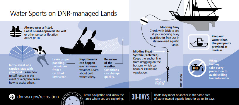
To access DNR's aquatic lands with a powerboat, you'll need a registered and insured boat. Check with DNR to see if your mooring buoy qualifies for free use in state-owned aquatic lands. You can moor or anchor your boat in the same area of state-owned aquatic lands for up to 30 days. DNR encourages mooring buoy owners to use the helix anchor system, which keeps the anchor line from dragging on the water floor and damaging marine habitat.
Remember to always wear a Coast Guard-approved life vest. Be aware of changes in weather and know the area you're navigating.
CAMPING: IT'S ALWAYS FREE
It’s easy to get out and explore Washington when your Discover Pass gives you access to 80 free first come, first served campgrounds managed by DNR. Our campsites offer a primitive camping experience. Go deep into the forest beneath towering trees, rest beside babbling creeks, or even set up your tent beachside along the Salish Sea. Find your next adventure with our Interactive Recreation Map and check the status of our campgrounds here.
While all of our campgrounds are first come, first served, there are a limited number of reservation campsites available at the Elbe Hills ORV Campground in Elbe Hills.
Before you go
Unless otherwise posted, you can stay 10 days in a 30-day period at any of DNR's campsites. During your stay, please practice leave no trace principles and pack out what you pack in. Quiet hours are between 10 p.m. and 7 a.m. Enjoy campfires in approved fire pits in designated campgrounds only.
Dispersed camping, camping outside of our designated campgrounds, is allowed in some of our forests. Dispersed camping is not allowed at day-use sites. Toilets, picnic tables, trash cans, drinking water, and fire pits are not available in the backcountry. Please follow Leave No Trace principles and pack out everything you pack in. Dispersed fires are prohibited.
Don't Move Firewood
You can help protect Pacific Northwest forests by preventing the spread of invasive species. Firewood can carry insects and diseases that can threaten the health of our western forests. Please purchase your firewood near your campsite. Visit Dontmovefirewood.org for more information.
If you love camping, consider becoming a volunteer campground host. Learn more here.

HANG GLIDING & PARAGLIDING
Want to see DNR-managed lands from above? Lift off from Tiger Mountain State Forest's Poo Poo Point or Blanchard Forest's Samish Overlook. DNR-managed land uniquely offers paragliding and hang gliding opportunities.
Plan your trip with our statewide recreation map. A Discover Pass is required to access recreation sites on DNR-managed lands.

HIKING
Did you know many of the most popular (for good reason) hikes in Washington are on DNR-managed land? Our state lands are home to classics like Mailbox Peak, Mount Si, and Blanchard Forest's Oyster Dome. But there’s so much more for you to explore. DNR manages 1,200 miles of trail, and that number continues to grow.
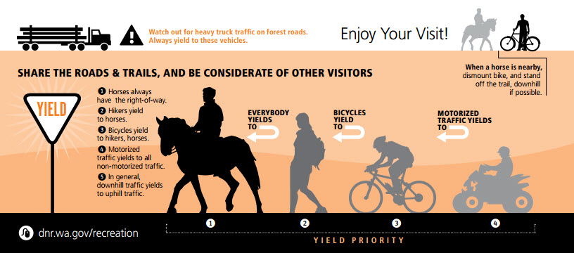
Please remember to practice Leave No Trace principles and only hike within your own abilities. If you're hiking with a dog, make sure it's leashed. All recreation activities must yield to horses and pack animals.
Before you head out on your next hike, always make sure someone knows where you're going and when you're expected to be back.
Don't forget your 10 Essentials:
-
Navigation (Map, compass, GPS system)
-
Illumination (Flashlight, headlamp, extra batteries)
-
Sun protection (Sunscreen, sunglasses, hat)
-
Insulation (Jacket, gloves, rain gear)
-
First aid
-
Fire (matches, lighter, fire starters)
-
Tools (repair kit, multi-tool, knife, duct tape)
-
Extra food
-
Extra water
-
Shelter (tent, space blanket, tarp, bivy)
HORSEBACK RIDING & PACK STOCK
There’s nothing quite like experiencing Washington from the back of a horse. Get out and explore new areas from one of DNR’s several horse camps around the state. Load up the trailer and visit Sahara Creek Horse Camp in Elbe Hills State Forest, Green Mountain Horse Camp in Green Mountain State Forest, or Margaret McKenny Campground in Capitol State Forest. You can also head out for a day trip and ride in the Les Hilde Trail System in Skagit County, from the Whites Ridge Trailhead in Ahtanum State Forest, and many more.
Pack Stock Use
Areas open to horseback riding also allow a variety of pack stock, including llamas, mules, goats, alpacas, and donkeys so you can enjoy a hike or horseback ride with your pack animal.
HUNTING & FISHING
Hunting
DNR manages more than 3 million acres of state trust lands that are accessible for hunting. Accessing DNR land for hunting requires a Discover Pass for your vehicle. Washington Department of Fish and Wildlife oversees game management units on DNR-managed lands. Head to the Washington Department of Fish and Wildlife for more information about hunting in Washington.
DNR Natural Resources Conservation Areas (NRCAs) are open to hunting per WDFW rules in remote areas and not in proximity to public access sites and trails; site-specific restrictions may be noted in management plans and onsite signs. Access to DNR Natural Area Preserves (NAPs) for hunting is determined through a site-specific management plan; most NAPs are closed to wildlife and plant removal unless approved by DNR in an adopted plan or as a resource management activity. To learn about conservation at DNR, visit our Natural Areas Program. [WAC 332-52 for public access; RCW 79.71.070 for NRCA management; 79.70.030(1)(b) for NAP management]
In partnership with the Washington Department of Fish and Wildlife, the Recreation Conservation Office, the U. S. Forest Service, and private timber companies, DNR offers a disabled hunter road access entry program by drawing only. The Road Access Entry Program provides hunters who have lower extremity mobility disabilities access into areas with fewer barriers and vehicle distractions.
When you're hunting, please be aware of other recreationists and brush gatherers in the forest.
Fishing
In addition to the rivers passing through DNR managed lands, we also offer fishing at more than 30 day-use recreation sites near lakes. Head south near the Oregon border for catch-and-release fly-fishing at Merrill Lake near Vancouver or venture east for rainbow trout fishing at Leader Lake near Okanogan.
For more information, fishing guidelines and fish stocking timelines, visit the Washington Department of Fish and Wildlife's website.
MOUNTAIN BIKING
Mountain bike trails on DNR-managed land are second to none. From riding East Tiger Mountain, bombing down Thrillium Trail in Yacolt Burn State Forest, and climbing Little Larch in Capitol State Forest, your next adventure is out there.
We’re also working with our partners to expand mountain biking opportunities in Raging River State Forest by creating an impressive 60-plus-mile non-motorized trail system with future connectivity to trails in nearby Taylor Mountain and Tiger Mountain. Stay up to date on this project and others here.
Remember to be safe and always wear a helmet when you're mountain biking. Bike within your own abilities and yield to other non-motorized trail users. Practice caution on wet and muddy trails to protect them from damage.
Note: E-bikes or electronic bikes are considered motorized vehicles and are therefore allowed only on DNR trails that allow off-road vehicles.
NATURE VIEWING & DAY USE AREAS
Head to one of our day-use sites to take advantage of lovely views and natural settings. DNR manages many beautiful picnic areas and interpretive sites for you to enjoy. Visit Woodard Bay Natural Resources Conservation Area in the spring to see harbor seals and their pups cruise through the chilly water as eagles and blue herons fly overhead. Come back on any late summer evening to see nearly 3,000 bats from Washington’s largest myotis bat colony take to the skies for their dinner.
Whether you're looking for a quick bite to eat near cascading falls, like Yacolt Burn State Forest's Dougan Creek, or on the shore at Murdock Beach on the Olympic Peninsula, there's a serene spot for you and your family to enjoy on DNR-managed land.
Please practice Leave No Trace principles by always packing out what you pack in to the landscape. And remember, dogs are unfortunately not allowed in any of our Natural Resource Conservation Areas or Natural Area Preserves in order to protect delicate habitat and wildlife. Dogs must remain on leash at all other sites.
RIDING OFF ROAD VEHICLES
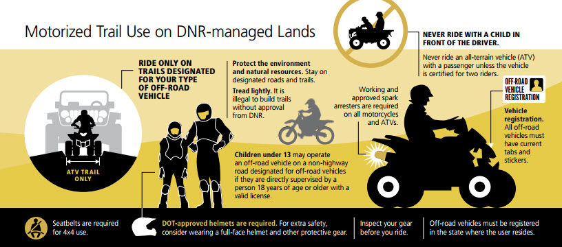
Did you know DNR has more than 400 miles of motorized recreation trails for you and your family to enjoy? Try out trails in Yacolt Burn, Walker Valley, Reiter Foothills Forest, Elbe Hills State Forest, Tahuya State Forest, Capitol State Forest, Little Pend Oreille, Beverly Dunes, and the Ahtanum State Forest.
DNR also manages a Green Dot Road system in partnership with the Washington Department of Fish and Wildlife and private landowners to provide opportunities for dispersed recreation such as camping, hunting, off-road vehicle riding, and wildlife viewing.
Keep your off-road vehicle trips safe and fun. Don't forget you must:
-
Have an approved spark arrester
-
Have current tabs and stickers
-
Wear a DOT-approved helmet
-
Ride on trails designed for your off-road vehicle.
-
Not ride after dark.
-
A Discover Pass is required for vehicle access to DNR-managed lands. Motorcycle riders should carry the pass with them.
ROCK CLIMBING
Washington is a climber’s paradise with plenty of sport and trad routes just waiting to be sent. DNR offers rock climbing as a dispersed recreation activity outside of developed recreation facilities or trails. Here’s the beta: Take a trip into the Mount Si Natural Resources Conservation Area, get pumped on some of the best bouldering near Seattle at the Gold Bar Boulders, and enjoy a climb with an island view at Oyster Dome in Blanchard Forest.
In 2018, DNR worked with the Access Fund and Washington Climbers Coalition to develop the Far Side Climbing Area in the Middle Fork Snoqualmie Natural Resources Conservation Area. The Far Side Climbing Area informally existed for years, but this project provided access signs for the trail junctions and maps of the area. Far Side offers predominately bolted routes ranging in difficulty from 5.6 to 5.12a. There are also a handful of trad lines and six multi-pitch options.
Check out Mountain Project for detailed climbing information and contact the region office near the area you're interested in climbing before you make the drive.
SNOW ACTIVITIES
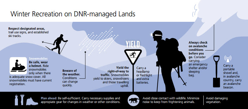
We’re going to go ahead and say it: High Hut, a backcountry hut in Tahoma State Forest, is the best place to go for dramatic views of Mt. Rainier in the winter—if you have what it takes to make the strenuous snowshoe trip up there. High Hut is one of three huts and a yurt on the 50-mile Mount Tahoma trail system that are open to the public for day trips from 7 a.m. to 7 p.m. and available for overnight stays by reservation through the Mount Tahoma Trails Association.
But that’s just one of the opportunities available to keep the adventures rolling on DNR-managed land in the winter. You can also enjoy snowshoeing and cross-country skiing at DNR sno-parks, such as the Lily Lake Winter Recreation Area. Maybe snowmobiling is more your thing. If that’s the case, check out Red Saddle and Whites Ridge winter recreation trailheads.
To access a sno-park with your vehicle, you will either need an annual Sno-Park Permit or a one-day Sno-Park Permit. For more information, visit Washington State Parks and check in with your region's DNR office for local conditions.
Be safe while you're out there. Carry a headlamp or flashlight and extra batteries when you go into the backcountry. Beware of changes in weather and always check on avalanche conditions before you go. Plan ahead and carry necessary supplies and appropriate gear should you need it.
TARGET SHOOTING
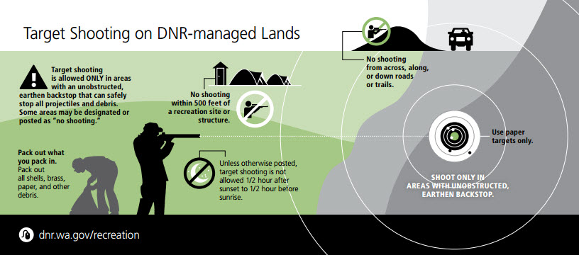
Target shooting is allowed on some of our landscapes, though the safest place to target shoot is at the shooting range in your local community. Target shooting is allowed on DNR-managed land only in areas that meet criteria identified in WAC 332-52-145, which includes having an unobstructed, earthen backstop that can safely stop all projectiles and debris. Some areas may be designated or posted as "No Shooting" to ensure public safety.
No shooting within 500 feet of a recreation site or structure. Unless otherwise posted, target shooting is not allowed one-half hour after sunset to one-half hour before sunrise. Don't shoot across, along, or down roads or trails. Use manufactured targets only. Exploding targets and tracer bullets are prohibited. Avoid hazardous areas unsuitable for target shooting by contacting the region for more information regarding the area you have in mind. See our graphic guide below (click to enlarge) for more information.
And please, remember to pack out all shells, brass, paper, and other debris.
Want to know more about how we're creating a vision for recreational target shooting? Click here.
Other Power-Driven Mobility Devices (OPDMD)
In accordance with the Americans with Disabilities Act (ADA), DNR allows individuals with mobility issues to use Other Power-Driven Mobility Devices (OPDMD) on many of our recreation trails and facilities. Please see the OPDMD Use – Department Managed Recreation Facilities and Trails Policy for further information.
Please note that OPDMDs are treated as motorized vehicles on roads, which may prohibit motorized use. Please refer to DNR’s below map of facilities and trails that prohibit OPDMD use before heading out, as the status may be subject to change.
DISCLAIMER: This map uses DNR's latest location data and is subject to change. This policy is for facilities and sanctioned trails only and does not apply to areas without public access, or on DNR-managed roads. Some Natural Areas do not allow public access and have management considerations that prohibit OPDMD use, and have been included in the map for clarity. If you are a person with a mobility disability and considering using an OPDMD on DNR-managed land, be sure to follow all requirements found in the OPDMD Allowed Uses and Operating Requirements.
If you would like to request a device-specific audit for a particular trail, please email recreation@dnr.wa.gov.
Trail Maps & Green Dot Road Maps
Trail Maps
Green Dot Road Maps

GEOCACHING & OTHER ACTIVITIES
Geocaching
Some of DNR’s most-loved recreation destinations are also home to geocaches hidden for players to find and discover.
Before you leave on your next geocaching adventure, don’t forget the Leave No Trace principles. Never create your own trails while searching for geocaches. Our landscapes are home to delicate habitat and wildlife. Please stay on the trail to avoid interfering with sensitive species.
Before you leave on your next geocaching adventure, don’t forget the Leave No Trace principles. Never create your own trails while searching for geocaches. Our landscapes are home to delicate habitat and wildlife. Please stay on the trail to avoid interfering with sensitive species.
To find geocaches hidden in DNR working forestland, visit Geocaching.com or use the Geocaching app and find coordinates in an area near you. Using the app or a GPS-enabled devise, navigate to the geocache’s coordinates. Once you find a geocache, you can log your experiences online to earn points.
Harvesting
You may harvest mushrooms, berries, floral greens, and other select resources for personal use only from some areas on DNR-managed lands. Harvesting of any forest products from DNR-managed campgrounds and picnic sites, natural area preserves or natural resources conservation areas is prohibited, unless the harvest is specifically included in the site's management plan. No reselling.
-
Mushrooms: Limited to three gallons of a single species per day, not to exceed nine gallons plus one mushroom per year.
-
Berries: Limited to three gallons of a single species per day, not to exceed nine gallons per year.
-
Brush and ferns: Root ball removal, not more than two plants per person, per day. Not more than four plants per person per year.
-
Cones: Not to exceed five pounds of cones per day.
-
Bear grass: Not more than five pounds per person per day, not more than 15 pounds per person per year.
-
Conks: All species, not more than five conks per day.
-
Seaweed: Not to exceed 10 pounds wet weight per day per person. For detailed harvesting information, click here.
-
Firewood: Collection by permit only. Limited to six cords per person, per year. Learn more.
Rockhounding
Washington has an extraordinary variety of rocks and fossils. Collectors have the opportunity to find beautiful agates, amethysts, garnets, jaspers, opals, and even the occasional nugget of gold. Before heading out to rockhound, you will need to review the rules, regulations, and guidelines available at dnr.wa.gov/rockhounding. Please contact our region offices for more information about suitable locations for rockhounding.
Metal Detecting
Metal detecting is permitted on DNR-managed land so long as it does not impact any archeological, tribal, or historic artifacts. Meteorites, vertebrate fossils, or any archeological or historic artifacts cannot be collected without a permit due to the rarity and the importance to science. Permits will only be granted for scientific purposes.
No archaeological resource or artifact, may be removed from the site at which it was found. Any such find must be immediately reported to the Recreation Manager (360) 902-1600 who will contact Agency archaeologists. It is unlawful to remove any historic or prehistoric archaeological resource without a permit per RCW 27.53.060.
Visitors must observe all laws and regulations while metal detecting on DNR-managed land. Please observe Leave No Trace principles while metal detecting and follow the guidelines established by WAC 352-32-235:
-
Never destroy or disturb park facilities, natural features, or historical or archeological resources.
-
Limit digging implements to ice picks, screwdrivers and probes not to exceed two inches in width and sand scoops not to exceed six inches in width and eight inches in length, containing perforations no less than one-half inch in width, to be used only on sand surfaces. Any holes dug shall be limited to six inches maximum depth and shall be immediately refilled and the surface restored to its earlier condition.
-
Properly dispose of all found or recovered trash and litter.
-
Conduct yourself with thoughtfulness, courtesy and consideration for others, and not interfere with other recreational activities. An operator shall not allow any emitted metal detector sound audible to other park users.
