
Olympic Peninsula Forests
|
|
Attention: Alerts and Closures
Recreation alert: Expect possible delays and use caution when driving on forest roads. Coppermine Bottom, Upper Clearwater, Yahoo Lake and South Fork Hoh campgrounds have forest management operations along their respective access roads.
Recreation alert: Road work and logging activities along the PA-H-1000 road system will directly impact the foothills multi-use trails effective immediately. Use extreme caution when on or near roads as heavy truck traffic and machinery will be present. For your safety, segments of the trail system may be closed and will be marked in the field.
Recreation alert: Dispersed campfires (those not in a designated DNR-installed fire ring at an official campground) are not permitted in the Olympic Peninsula Forests. View list of campsites.
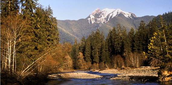
The Department of Natural Resources (DNR) manages various forestlands throughout the Olympic Peninsula as working forests. These lands provide sustainable revenue in support of public services.
The forests of the peninsula support timber production, biomass byproduct sales, communication tower leases, and other activities help to fund local services, prisons, universities, and construction of public K-12 grade schools throughout Washington. In addition to earning income, these activities contribute to the local economies of many area communities, as well as the entire state. A notable landscape on the peninsula is the Olympic Experimental State Forest, which is unique among forest trust lands for its role as a place where research is done to inform DNR's statewide efforts to integrate revenue production and ecosystem values.
The Olympic Peninsula’s undeveloped working lands provide habitat for native plants and animals, water retention and quality benefits, and many scenic tourism and recreation opportunities.
Recreation
DNR recreation opportunities on the Olympic Peninsula include hiking, horseback riding, mountain biking, motorcycling, and off-road vehicle riding. The majority of the campgrounds have river or lake access for boating, fishing, and other water activities. The region is located near the Olympic National Park, Hoh Rain Forest, Olympic National Forest, Olympic Experimental State Forest, as well as the many coastal beaches in the region.
We Want to Hear From You
We are always looking to improve user experiences on our trails systems and we want to hear from you. Please take a few minutes to complete this survey about the recreation you enjoy in the Olympic Region. We'd love to hear your ideas on how we can continue to improve.
Olympic Peninsula Tips
- Olympic Peninsula campgrounds are open year-round.
- The maximum stay length is seven days within a 30-day period.
- Practice quiet hours from 10 p.m. to 6 a.m.
- Dispersed camping, or camping outside of designated campgrounds, is allowed.
- Dogs are allowed on DNR-managed land on the Olympic Peninsula on a leash. Horseback riders may bring unleashed dogs if they are controlled by voice command.
- Be alert for other road users, ranging from heavy vehicles to bicycles, and check your speed accordingly.
Other tips for your visit
- Don’t forget your Discover Pass! Learn more about it at DiscoverPass.wa.gov
- Campsites are available first-come, first-served at no additional cost with the purchase of a Discover Pass.
- Enjoy a campfire in approved fire pits in designated campgrounds only. Always check for burn restrictions before lighting a campfire.
- Don't Move Firewood. Help protect Pacific Northwest forests by preventing the spread of invasive species. Firewood can carry insects and diseases that can threaten the health of our western forests. Please purchase firewood near your campsite. Find more information here.
Leave No Trace
For your safety and the safety of our wildlife, please follow the seven principles of Leave No Trace. You can brush up on them here. Food and garbage that is left behind or improperly disposed of can attract wildlife and create potentially dangerous situations for visitors. Please pack out all food items and garbage. NEVER feed wildlife.
Recreation sites
Northern Olympic Peninsula
Built and designed by local volunteers, the 3-mile Colville Trails system is open to mountain bikers and provides directional natural surface mountain bike trails for beginner riders looking to progress their skills. Visit our trail map for more information.
Directions: Starting at intersection of US Highway 101 and US Highway 112, head west for 2.15 miles. Turn left (south) onto Dan Kelly Road and proceed for .75 miles (road turns right). Take a left from Dan Kelly Road onto Colville Road and then take an immediate left into the parking area. Get directions.
Foothills Trail
Just below Hurricane Ridge and 5 miles south of Port Angeles, the 11-mile Foothills trail system is open to hikers, horseback riders, mountain bikers, and motorcycles. Visit our trail map for more information.
Amenities: Picnic tables, kiosk and ATV loading ramp
Directions: Start in Port Angeles at West 8th Street and South Pine Street. Go south on Pine (Old Black Diamond Road) for 4.8 miles. Turn left on Little River Road (gravel road). Go 1.3 miles and parking area is on left.
Little River Trail
The Little River Trail begins just a few miles west of Port Angeles and provides access to Hurricane Ridge and the northern end of Olympic National Park. It winds through mature hemlock trees and alpine meadows.
Directions: Start in Port Angeles at 8th and Pine. Go south on Pine 4.8 miles. Turn left on Little River Road. Go .1 miles. Trailhead, parking on left. Trail access to Hurricane Ridge (mountain bike access to Olympic National Park boundary only). Get directions.
Reade Hill Trailhead
DNR's Reade Hill Trailhead provides access to the 4.2-mile Reade Hill Trail, which passes through four types of forest stands. Interpretive signs along the trail will provide information and illustrations to help hikers, mountain bikers and horseback riders understand the varying forest types and how they relate to DNR's obligation to state beneficiaries. Click here for a map of Reade Hill.
DNR's Reade Hill Trailhead provides access to the 4.2-mile Reade Hill Trail, which passes through four types of forest stands. Interpretive signs along the trail will provide information and illustrations to help hikers, mountain bikers and horseback riders understand the varying forest types and how they relate to DNR's obligation to state beneficiaries. Click here for a map of Reade Hill.
Directions: About 1 mile south of Forks on Highway 101 follow signs to the Olympic Natural Resource Center (ONRC). Turn east/south onto the road to ONRC. Take first left up the gravel road, trailhead parking is approximately .5 mile on left.
Lyre River Campground
This campground is located near Lyre River in a mature riparian forest, about a half-mile upstream from where the river empties into the Strait of Juan de Fuca. A popular camp for anglers, Lyre offers good salmon fishing during fish migrations. The site has 11 campsites, shelter, two toilets and potable water. View our map for more information. Campsites can accommodate up to a 20-foot RV, though size may vary by site.
Directions: Start on SR-112 between mileposts 46-47. Go north on paved road .4 mi. Turn left to the site. Get directions.
Murdock Beach
Murdock Beach, located on the Strait of Juan de Fuca, gives visitors a view of Vancouver Island. This is the only public beach access for 12 miles between Camp Hayden and the East Twin River. Toilet located at the parking lot.
Directions: Start at milepost 44.6 on SR-112. Turn north on PA-S-2500. Go .3 miles. Turn right on PA-S-2510. Follow to the beach. Get directions.
Sadie Creek Multi-Use Trails and Campground
Sadie Creek Trailhead, a 30-mile trail and road system on the Olympic Peninsula. The trail climbs to about 2,500 feet, giving visitors views of the Strait of Juan de Fuca, Vancouver and the San Juan Islands. Enjoy six first-come, first-served campsites at this trailhead. Campsites can accommodate up to a 30-foot RV, though size may vary by site.
Download a trail map of Sadie Creek.
Directions: Start on SR-112 between mileposts 42-43. Turn south on East Twin River Road (Forest Service Road 3040). Go .1 miles. Turn right to the trailhead. Get directions.
Sadie Creek 4x4 Trail
Sadie Creek 4x4 is a 8-mile network of tight and technical trails providing the user with a rustic off-road experience. The trails weave through forests of varying ages and offer unobstructed views of the Strait of Juan de Fuca and Vancouver Island. View a trail map.
View a map trail and bridge closure
Directions: Start on SR-112 between mileposts 42-43. Turn south on East Twin River Road (Forest Service Road 3040). Go .1 mile and turn right into the parking area. Trail entrance is on the north side of SR-112 through qualifier behind a locked gate.
Striped Peak Vista
Striped Peak Vista Trail and Trailhead offer spectacular views of the Strait of Juan de Fuca and Vancouver Island. The 6.5 mile loop trail takes hikers through old growth Douglas-fir and Cedar trees, alongside a waterfall to a rocky cove, and to a loop trail at the striped peak summit. View a trail map of the Striped Peak Vista and Trailhead.
Directions: From SR-112 at milepost 53.9 go north on Camp Hayden Rd. for approximately 3.5 miles and enter Salt Creek Recreation Area on right. Go through the entrance station and trailhead parking is immediately on the right. Get directions.
Western Olympic Peninsula
Bear Creek Campground
This 16-campsite campground is located along the Sol Duc River. Visitors to the campground can take a hiking trail to the river and fish along its banks. Amenities include a scenic overlook, two toilets. Campsites can accommodate up to a 30-foot RV, though size may vary by site.
Directions: Located on the south side of US Highway 101 at milepost 206. Get directions.
Coppermine Bottom Campground
Along the Clearwater River, Coppermine Bottom Campground offers a secluded and primitive campground to enjoy the Olympic Peninsula. Campsites can accommodate up to a 30-foot RV, though size may vary by site.
Directions: Start on US Highway 101 at milepost 147. Go north on Hoh-Clearwater Mainline (paved) for 12.6 miles. Turn right on C-1010 Road (gravel, one lane) and go 1.5 miles. Site is on left. Get directions.
Cottonwood Campground
Cottonwood Campground is a primitive campground near the Hoh River located close to the Olympic Experimental State Forest. Campsites can accommodate up to a 30-foot RV, though size may vary by site.
Directions: Start on US Highway 101 between mileposts 177-178. Go west on Oil City Road (paved) for 2.3 miles. Turn left on H-4060 (gravel). Go .9 miles to site. Get directions.
Hoh Oxbow Campground
Located near the Hoh River near the edge of the Olympic National Park, Hoh Oxbow Campground offers pristine camping among a dense, mossy forest of hemlock and fir. Facilities include eight campsites, toilet. Campsites can accommodate up to a 30-foot RV, though size may vary by site.
Directions: Start on US Highway 101 between mileposts 176 and 177. Site is east of the highway. Get directions.
Minnie Peterson Campground
This nine-campsite campground is on the edge of the Hoh Rain Forest in the Olympic Experimental State Forest and provides visitors a peaceful setting along a creek. Campsites can accommodate up to a 30-foot RV, though size may vary by site.
Directions: From Willoughby Creek continue on Hoh Rain Forest Road for 1 mile. Site is on left. Get directions.
South Fork Hoh Campground
On the Hoh River at the edge of Olympic National Park, South Fork Hoh campground offers a primitive camping experience in the Olympic Peninsula. Campsites can accommodate up to a 30-foot RV, though size may vary by site.
Directions: Start on US Highway 101 at milepost 176. Go east on Hoh Mainline (paved) for 6.6 miles, then left on H-1000 Road (paved one lane, then gravel one lane) for 7.4 miles. Site is on right. Get directions.
Upper Clearwater Campground
The Upper Clearwater Campground is a low-impact recreation site near the Clearwater River. This campground is part of the 2,323-acre Clearwater Corridor Natural Resources Conservation Area that supports important elk habitat, Sitka spruce trees, and riparian habitat along the Snahapish and Clearwater Rivers. The campground features six campsites in a secluded forest setting and includes vault toilets.
Directions: From the intersection of Highway 101 and Clearwater Road, travel north on Clearwater Road (on the Hoh Mainline/Snahapish Mainline) to Upper Clearwater Road; just after Snahapish River, turn right and travel about 3 miles on the C3000 Road. Get directions.
Yahoo Lake Campground
At 2,400 feet, Yahoo Lake campground is a remote campground on the Olympic Peninsula. It offers lovely views of Yahoo Lake. There is a 500-foot trail from the parking area to the water.
Directions: From Upper Clearwater Campground entrance continue on C-3000 Road for .8 miles. Turn right on C-3100 Road (paved one lane, then gravel one lane). Continue 6.1 miles to trailhead. Get directions.
Other recreation opportunities
The nearby Shipwreck Point Natural Resources Conservation Area also offers low-impact recreation opportunities. Or, visit the Clearwater Corridor Natural Resources Conservation Area to camp at the Upper Clearwater Campground. Use our statewide interactive recreation map to find recreation opportunities near you.
