
Naneum Ridge State Forest
Attention: Alerts and Closures
Recreation alert: Chelan Butte Sky Park no campfires allowed.
The 71,500 acre Naneum Ridge State Forest, located south of Wenatchee primarily in Kittitas County and near the Milwaukee Road Corridor, is a working forest managed by the Department of Natural Resources (DNR) to provide sustainable revenue in support of public services. Timber production, communication tower leases, and other activities help to fund local services, prisons, universities, and the construction of public K-12 grade schools throughout Washington.
In addition to earning income, Naneum Ridge's undeveloped working lands provide habitat for native plants and animals, water retention and quality benefits, and diverse recreation opportunities.
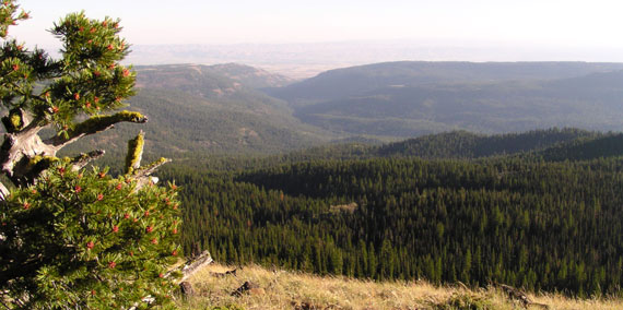
Recreation
Naneum Ridge State Forest is open year-round for dispersed recreation activities along 109 miles of green dot roads in the forest. DNR manages a Green Dot Road System in partnership with the Washington Department of Fish and Wildlife and private landowners to provide opportunities for dispersed recreation such as camping, hunting, hiking, off-road-vehicle riding, and wildlife viewing. Naneum Ridge State Forest also has about 279 miles of forest management roads for hiking, horseback riding, and mountain biking.
Naneum Ridge State Forest Tips
- Snow trails groomed Dec. 15 - April 1.
- Dogs are allowed in Naneum State Forest but must be kept on a leash. Horseback riders may bring unleashed dogs if they are controlled by voice command.
- Be alert for other road users, ranging from heavy vehicles to bicycles, and check your speed accordingly.
Green Dot Road Maps
View a PDF map of green dot roads in the Naneum Ridge State Forest. Learn more about using our free geo-locator mobile maps.
Milwaukee Road Corridor Information
Washington State Parks now manages the entire trail from Beverly to the Idaho border as the Palouse to Cascade Trail (formerly known as the Iron Horse Trail).
A permit is now required for this section of the trail. Please note that the Milwaukee Road Corridor is closed between Beverly and Smyrna due to a fire-damaged trestle over Crab Creek.
Other tips for your visit
- Don’t forget your Discover Pass! Learn more about it at DiscoverPass.wa.gov
- Campsites are available first-come, first-served at no additional cost with the purchase of a Discover Pass.
- Enjoy a campfire in approved fire pits in designated campgrounds only. Always check for burn restrictions before lighting a campfire.
- Don't Move Firewood. Help protect Pacific Northwest forests by preventing the spread of invasive species. Firewood can carry insects and diseases that can threaten the health of our western forests. Please purchase firewood near your campsite. Find more information here.
Leave No Trace
For your safety and the safety of our wildlife, please follow the seven principles of Leave No Trace. You can brush up on them here. Food and garbage that is left behind or improperly disposed of can attract wildlife and create potentially dangerous situations for visitors. Please pack out all food items and garbage. NEVER feed wildlife.
Surrounding Recreation Sites
Beverly Dunes ORV Area
Beverly Dunes offers riders of all ages year-round sand dune riding near Lower Crab Creek. Open to 4x4, ATV, UTV, and motorcycles. With the exception of motorcycles, riders need to have a red flag mounted to their vehicle at least 108 inches above the ground. Campfires are not allowed. Learn more.
Directions: Start at I-90 and Highway 26 (east of Vantage Bridge) and turn south onto Highway 26. Go one mile and turn right on Highway 243. Go 6.7 miles and turn left on Lower Crab Creek Road. Go 1.8 miles and turn right into Beverly Dunes ORV Park. Get directions.
Chelan Butte Sky Park
This is a popular site for hang gliding and paragliding and offers unparalleled views of the surrounding area. Membership with the United States Hang Gliding and Paragliding Association required. Open until winter season snows blocks entrance road.
Directions: From Highway 97A on the southern lakeshore of Lake Chelan turn south onto Chelan Butte Road and drive 4.2 miles south to the top of Chelan Butte.
Recreation alert: No campfires allowed.
Manatash Ridge Trails
Manastash Ridge offers sweeping views of the Kittitas Valley and the Stuart Range. Take a hike along the ridge, grab your mountain bike, or take a scenic horseback ride. Dogs allowed on leash. Dispose of pet waste appropriately.
Directions: Take exit 101 off I-90 and travel south on Thorp Highway for two miles. Make a right onto Miller Road and continue to the junction with Robinson Canyon Road. There, Miller Road becomes Cove Road. Drive to the parking area at the end of Cove Road.
