
Tiger Mountain and Raging River State Forests
|
|
Attention: Alerts and Closures
Recreation alert: Segments of the Tiger Mountain Trail, Middle Tiger Trail, and Hobart Middle Tiger Railroad Grade are temporarily closed during road construction and timber harvesting operations. Trails will be reconstructed following timber harvesting and are anticipated to reopen Summer 2025. Please review the map for specific closure information.
Recreation alert: The Grand Canyon Trail is temporarily closed due to an unsafe trail crossing.
The 13,745-acre Tiger Mountain State Forest, near the West Tiger Mountain Natural Resources Conservation Area, is one of DNR's most well-known forests. In 2009, 11,200 acres purchased to its south, including Rattlesnake Mountain, became Raging River State Forest.
As working state forests, Tiger Mountain and Raging River are managed by DNR to provide sustainable revenue in support of public services. Timber production, biomass byproducts, communication tower leases, and other activities by DNR in the forest help fund local services, prisons, universities, and the construction of public schools throughout Washington.
In addition to earning income, these undeveloped working lands provide habitat for native plants and animals, water retention and quality benefits, and diverse recreation opportunities.
Recreation
Located near Issaquah, Tiger Mountain and Raging River state forests offer a diverse range of recreation opportunities, including hiking, horseback riding, mountain biking, hang gliding, and paragliding.
Tiger Mountain and Raging River Tips
-
All Tiger Mountain trailheads are day-use only. No campgrounds are available. You may not camp outside of a designated campground.
-
Dogs are allowed at Tiger Mountain and Raging River if they are on a leash. Horseback riders may bring unleashed dogs if they are controlled by voice command.
-
Tiger Mountain State Forest is within the Snoqualmie Corridor, which is a no-shooting corridor for target shooting. The corridor also includes some of our natural areas.
-
Be alert for other road users, ranging from heavy vehicles to bicycles, and check your speed accordingly.
Hunting
Download a map of DNR-managed lands overlaid with game management units. Visit the Washington Department of Fish and Wildlife for more information about hunting regulations in Washington.
Other tips for your visit
- Don’t forget your Discover Pass! Learn more about it at DiscoverPass.wa.gov
Leave No Trace
For your safety and the safety of our wildlife, please follow the seven principles of Leave No Trace. You can brush up on them here. Food and garbage that is left behind or improperly disposed of can attract wildlife and create potentially dangerous situations for visitors. Please pack out all food items and garbage. NEVER feed wildlife.
Recreation Sites
Raging River Trail System
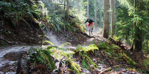
Just off Interstate 90, Raging River is a 17-mile mountain bike-oriented single-track trail system with opportunities for hikers. The trails range from easier to difficult and expert-only riding levels, located east of State Route 18 and south of Rattlesnake Mountain, offering expansive mountain views. The trail system is growing and will eventually expand to offer 35-plus miles of non-motorized trails.
Just off Interstate 90, Raging River is a 17-mile mountain bike-oriented single-track trail system with opportunities for hikers. The trails range from easier to difficult and expert-only riding levels, located east of State Route 18 and south of Rattlesnake Mountain, offering expansive mountain views. The trail system is growing and will eventually expand to offer 35-plus miles of non-motorized trails.
Directions: Take I-90 east to exit 27. Turn right. Travel 0.25 miles and park at the Snoqualmie Point Trailhead.
Tiger Summit
Just off State Route 18, Tiger Summit offers hiking, horseback riding, and mountain biking. The Tiger Summit Trailhead provides access to a dense trail network provide views of the Tiger Mountain State Forest and the surrounding Snoqualmie Corridor. Find out their allowed uses below.
Trail map here (Updated April 2019)
- 15 Mile RR Grade: Hike
- Forest Loop Interpretive Trail: Hike (ADA accessible)
- Grand Canyon Trail: Hike, horseback ride
- Hidden Forest Trail: Hike
- Hobart-Middle Tiger RR Grade Trail: Hike
- Horse By-Pass: Hike, horseback ride
- Inside Passage: Mountain bike, hike
- Middle Tiger Trail: Hike
- South Tiger Powerline Trail: Hike, horseback ride
- South Tiger Traverse: Hike, horseback ride
- Predator Trail: Mountain bike only
- Master Link: Mountain bike, hike
- The Legend: Mountain bike only
- Easy, Tiger: Mountain bike, hike
- Megafauna: Mountain bike only
- Crosshaul: Mountain bike, hike
The following trails are subject to seasonal closure:
- Bail Out: Hike, mountain bike
- Connector: Hike, horseback ride, mountain bike
- East Tiger Summit: Hike, mountain bike
- Fully Rigid: Hike, mountain bike
- Iverson Railroad: Hike, horseback ride, mountain bike
- Joyride: Hike, mountain bike
- NW Timber Trail: Hike, mountain bike
- Off-the-Grid: Hike, mountain bike
- Preston RR Grade: Hike, horseback ride, mountain bike
- Silent Swamp: Hike, mountain bike
Directions: From Issaquah, go east on I-90 to exit 25. Turn right onto SR 18. Go 4.5 miles to Tiger Summit. Turn right. Take Westside Road left .3 miles to site on right.
Visit West Tiger
The Chirico Trail, One View Trail, Tiger Mountain Trail, Bootleg Trail, Poo Poo Point, and West Tiger No. 1 trail connect hikers and horseback riders from Tiger Mountain State Forest to West Tiger Mountain Natural Resources Conservation Area.
Other recreation opportunities
You'll also find low-impact recreation opportunities in the nearby West Tiger Mountain Natural Resources Conservation Area, Middle Fork Snoqualmie Natural Resources Conservation Area, Rattlesnake Mountain Scenic Area, and the Mount Si Natural Resources Conservation Area. Use our statewide interactive recreation map to find recreation opportunities near you.
