
The Washington Geological Survey develops, produces, and publishes a large variety of maps and reports on the hazards faced by our state. This page contains a collection of these resources and a brief description of each item. Detailed information can be found in the map or report. All of the following resources can also be found on our Publications and Maps page, through the Washington Geology Library, or on the Geologic Information Portal.
Tsunami evacuation
|
Tsunami evacuation routes were developed to help coastal residents and visitors find safer locations in case of an earthquake and tsunami. The published brochures and walk time maps are for specific areas. The Geologic Information Portal has a Tsunami Evacuation single-topic map that allows you to search for addresses and locations of interest. The information on the portal and in the brochures is the same. |
|
Evacuation Maps
We offer two types of evacuation map products: walk time maps and evacuation brochures. To read more about these products and to download them, check out the tsunami evacuation maps webpage.
Mobile and Desktop Apps
The Northwest Association of Networked Ocean Observing Systems (NANOOS) has developed an interactive map of tsunami evaucation zones, routes, and assembly areas for both Oregon and Washington. They have a desktop site, and a mobile app available through the itunes store for free. NOAA has also developed a mobile app of tsunami evacuation routes for android devices.

|

|
|
NANOOS Web Visualization for tsunami evacuation zones |
NANOOS Mobile App for tsunami evacuation zones (for Apple devices) |
Tsunami inundation
|
Inundation maps show areas at risk of inundation by tsunamis that are generated from large earthquakes. These maps are based on model results from hypothetical earthquake scenarios on the Cascadia subduction zone, Seattle Fault, or Tacoma fault. |
|
Reports and Maps
We currently offer a variety of hazard maps covering different earthquake scenarios. To read more about these maps and to download them, visit our tsunami hazard maps webpage.
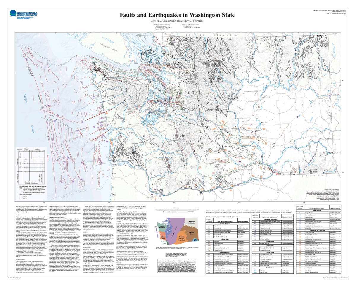
Active faults and earthquakes in Washington state
|
Geologists from the Washington Geological Survey map and characterize faults throughout the state every year. We also combine and publish these data for the entire state. The Geologic Information Portal has a Natural Hazards single-topic map that shows active faults and earthquakes. Click the "Seismogenic Features" button in the Map Contents window to display faults and earthquakes. |
|
Reports and Maps
Click below to download the 2014 state-wide compilation of active faults and earthquakes.
Seismic Scenario Catalog
|
The Washington State Seismic Scenario Catalog contains loss estimates for a suite of earthquake scenarios. These scenarios were selected to represent reasonable estimates of the most serious earthquake hazards everywhere in Washington as a basis for planning. Access the Seismic Scenario Catalog here. Note that the catalog was previously available on the Geologic Information Portal. The Cascadia subduction zone earthquake, Seattle Fault, and Tacoma Fault scenarios are still viewable on the Portal, but the other scenarios have now been moved to a separate webpage where you can better understand and download the datasets. |
|
NEHRP site class and liquefaction susceptibility
|
In response to the Nisqually earthquake of 2001, the Survey was awarded a grant by FEMA and the Washington Emergency Management Division to develop two types of earthquake hazard maps for every county in the state—liquefaction susceptibility maps, which outline areas where water-saturated sandy soil loses strength during earthquake shaking, and NEHRP (National Earthquake Hazards Reduction Program) site class maps, which outline areas where soils amplify ground shaking. The maps will be used by state and local governments to update existing hazard mitigation plans and to delineate geologically hazardous areas under the Growth Management Act. The Geologic Information Portal has a Natural Hazards single-topic map that contains the site class, liquefaction, and seismic design categories data. Click the "Ground Response" button in the Map Contents window. |
|
The Geologic Information Portal has a Natural Hazards single-topic map that contains the site class, liquefaction, and seismic design categories data. Click the "Ground Response" button in the Map Contents window.
Reports and Maps
This map shows all site class and liquefaction susceptibility maps for Washington, by county. Clicking on a county will display links to the published maps and reports.

Seismic design categories
Seismic Design Category Maps for Residential Construction were developed and published in 2007 as two PDFs. Click below to download a .zip file with both maps.

The Geologic Information Portal has a Natural Hazards single-topic map that contains the site class, liquefaction, and seismic design categories data. Click the "Ground Response" button in the Map Contents window.
Hazardous Minerals
|
The Survey maintains a database of hazardous mineral locations from mines or prospects known to have produced uranium, mercury, asbestos, or arsenic. The database also contains the locations of mapped ultra-mafic rocks that may potentially contain asbestos and a radon hazard map. The Geologic Information Portal has a data that shows hazardous mineral locations and radon hazards. Click the "Minerals" button in the Map Contents window. |
|
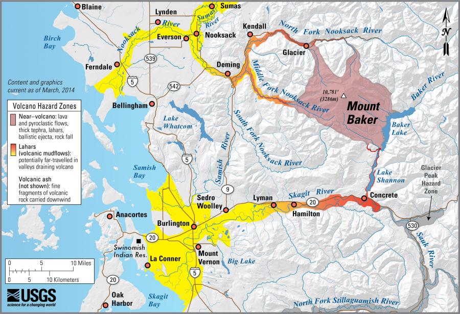
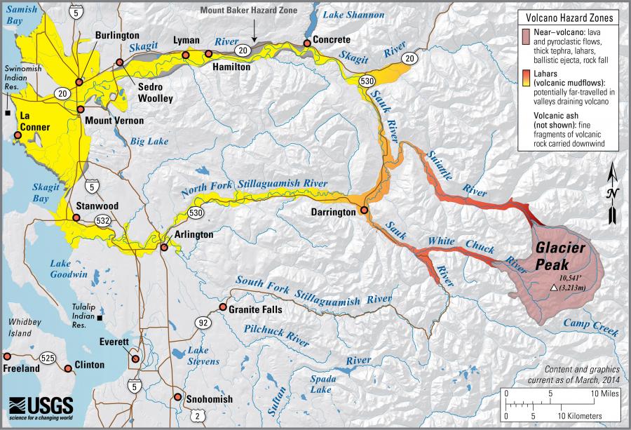
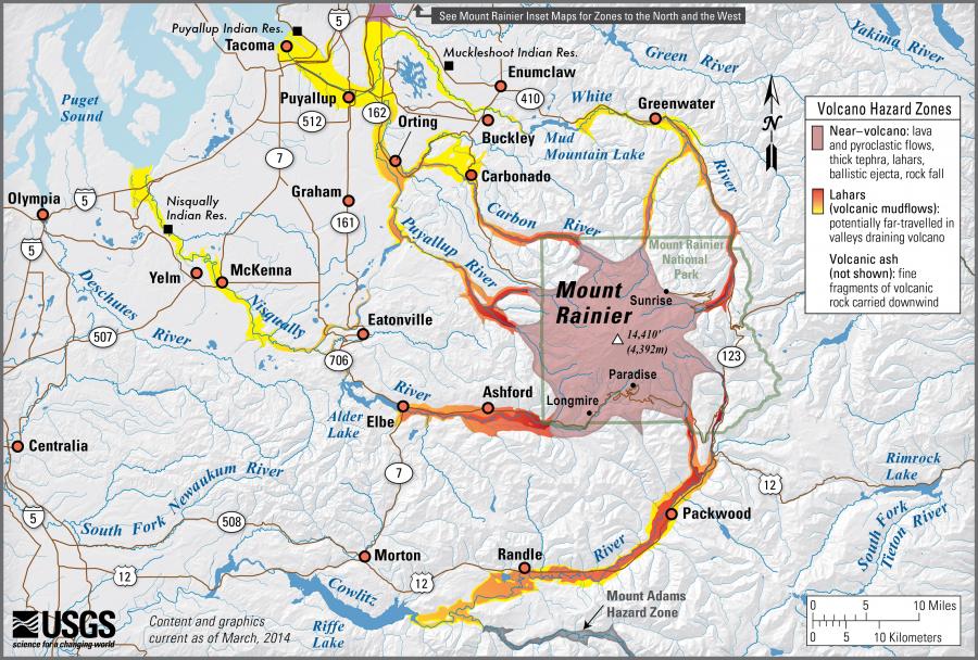
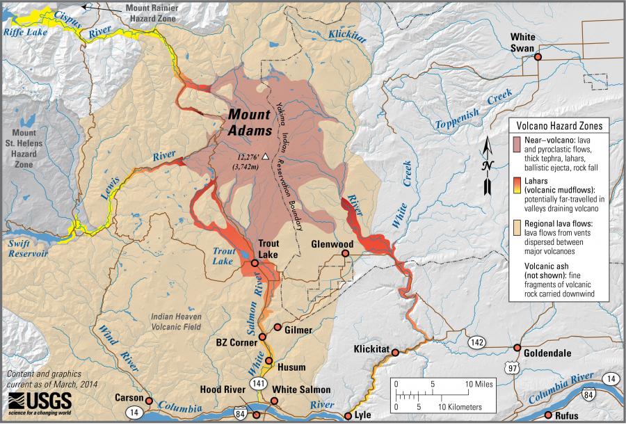
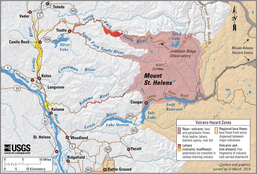
Lahar Hazards
|
The Survey works with the U.S. Geological Survey and the Washington Emergency Management Division to study and develop response plans for lahars. Geologists with the Survey have studied lahars as a part of ongoing efforts to map the geology of Washington state. These publications can be searched on the Washington Geology Library catalog. The Geologic Information Portal has a Natural Hazards single-topic map that contains lahar hazards and land parcels at risk from potential lahar scenarios. Click the "Volcanoes" button in the Map Contents window. |
|
Reports and Maps
The following maps show generalized lahar hazards for each of the major volcanoes in Washington. Each map is associated with a report. Check out the Geologic Information Portal (below the table) for detailed hazards near Mount Rainier.
Landslides and landforms
|
The Geologic Information Portal has a geologic map single-topic map that shows mapped landslides in the state. These landslides are compiled from existing geologic maps. The absence of a mapped landslide does not indicate the absence of landslide hazard. Click the "Landslides" button in the Map Contents window. |
|
Landslide inventories have been completed for several counties in Washington. To see a map of the available publications, visit our landslides webpage.
Inactive and abandoned mines
Many of Washington's metal mines are now abandoned, and the Survey has steadily made headway in inventorying the history, physical characteristics, and geologic and environmental hazards of over 60 abandoned mine sites or districts. Only the mines with more than 2,000 feet of underground development, more than 10,000 tons of production, or had a known mill site or smelter have been evaluated at this point.
Click on locations below to download Inactive and Abandoned Mine Land Reports.
