
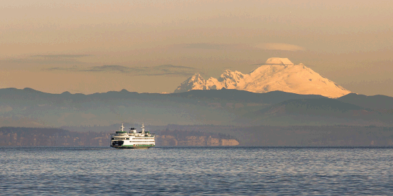
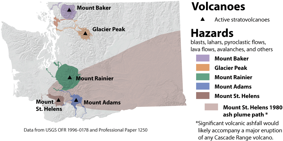
Washington has five volcanoes that are listed as high or very high threat potential: Mount Baker, Glacier Peak, Mount Rainier, Mount St. Helens, and Mount Adams. These volcanoes are part of the Cascade Range, a 1,200-mile line of volcanoes from British Columbia to northern California.
Many volcanoes in Washington are active and have had recent eruptions. Volcanoes do not erupt at regular intervals, so it is difficult to know exactly when or where the next eruption will happen.
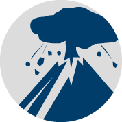
Many hazards come with living near volcanoes. Volcanic eruptions can send ash and volcanic debris into the air. Heat from the volcano can melt snow or ice and cause dangerous mudflows and debris flows called lahars. Molten rock called lava can erupt and flow downhill, destroying everything in its path.
How dangerous are the Northwest's volcanoes? Video by Oregon Public Broadcasting.
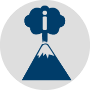
Volcanoes are also beautiful mountains that many people visit each year for recreation. Volcanoes are the most visual result of plate tectonics and are one of the few places on Earth where molten rock can reach the surface. There are even old volcanoes on other planets, such as Venus and Mars.
Click below to learn more about volcanoes, their hazards, who is at risk, and how to prepare for an emergency.
 Washington volcanoes |
 Volcanic hazards |
 Evacuation and preparation |
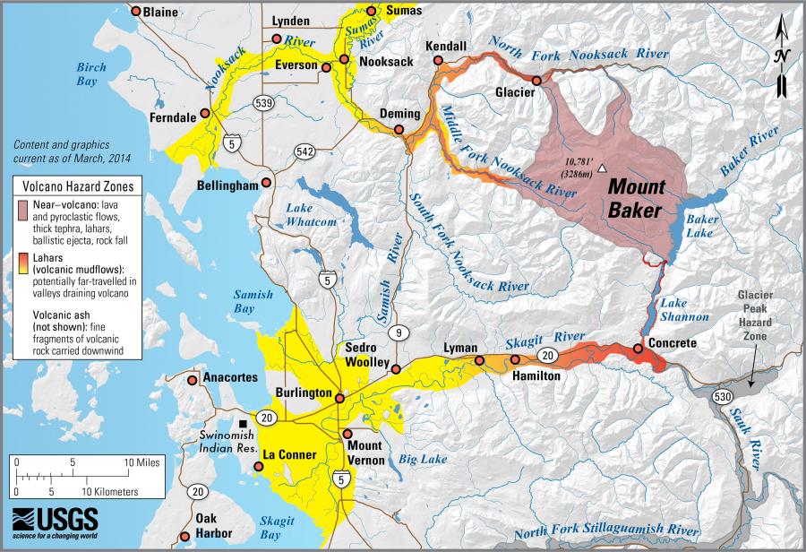
 Volcano hazard information map |
 Understand volcanoes |
 What we do |
 Volcano preparedness products |
 Fun volcano activities |
Washington volcanoes
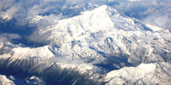
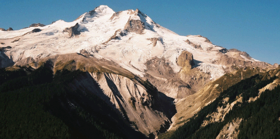
- Mount Baker
- Glacier Peak
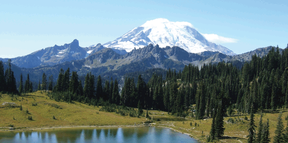
- Mount Rainier
- Mount St. Helens
- Mount Adams
-
Mount Baker from its lofty height above Puget Sound. Photo credit: Jonathan Miske, Flickr (Creative Commons).
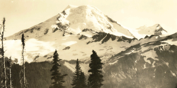
Photo of Mount Baker taken from Skyline Ridge, circa 1922. Photo credit: Clyde Banks.
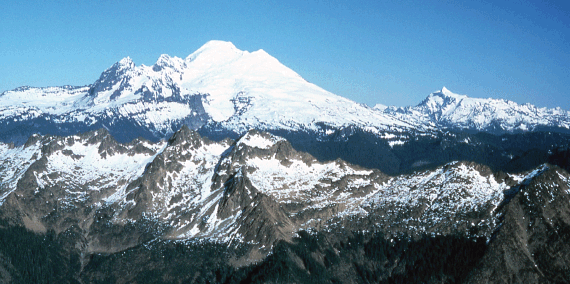
Mount Baker circa 1981, with the Twin Sisters in the foreground. Photo credit: A. Fiksdal.
Geology
Mount Baker produces andesitic lava flows, pumice, and lahars (volcanic mudflows).
Eruption and Lahar History
Mount Baker is one of the youngest Cascade volcanoes, and erupts infrequently. Its last major eruptive period occurred about 6,600 years ago, where large portions of the flank repeatedly collapsed generating massive lahars. There are additional reports of eruptions and lahars from the 19th century, and as recently as 1975, fumarole activity and snow melt ramped up dramatically for several years.
Steam and gas still issue from both Sherman Crater and the Dorr fumarole field on the northeast flank of the volcano today. Mount Baker holds the world record for most snowfall in a single season—95 feet in 1999!
Short visual tour of Sherman Crater, Mount Baker summit fumarole field. Video by Dave Tucker.
Links
Simplified
Hazard MapMore Info
Potential Volcanic Hazards from Future Activity at Mount Baker Local Resources
-
Geology
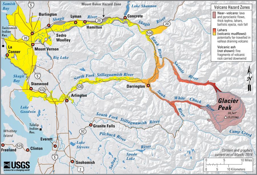
Sitting relatively low on the sklyline, Glacier Peak is mostly hidden from Puget Lowland residents, yet it is one of the more dangerous of the Cascade volcanoes. The volcano frequently and explosively produces dacitic lava flows, tephra, and far-reaching lahars (volcanic mudflows).
Geologic mapping has documented the extent of previous lahar runout in the Skagit and Stillaguamish River valleys. While Glacier Peak has shown no sign of eruption in the last few decades, the lahars deposits in the river valleys from past eruptions are a reminder of the hazard Glacier Peak poses to the communities living in the valleys adjacent to the volcano.
Eruption and Lahar History
Glacier Peak erupts frequently. The eruptions are typically explosive and occasionally voluminous. Most eruptions involve tephra, but many were accompanied by far-reaching lahars and dome-building.
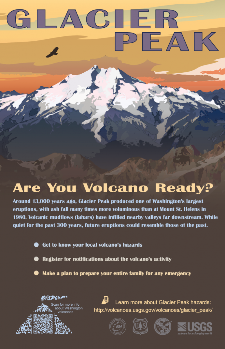
Glacier Peak has erupted multiple times in the last 15,000 years. About 13,000 years ago, a series of large tephra eruptions occurred, accompanied by numerous lahars—one eruption was many times the size of the Mount St. Helens 1980 eruption. Within the last 5,000 years, the volcano produced frequent lava dome eruptions and subsequent dome collapse and lahars. The most recent eruption was only ~300 years ago.
Links
Simplified
Hazard MapMore Info
Volcanic-Hazard Zonation for Glacier Peak Local Resources
-
Geology
Mount Rainier produces andesitic and dacitic lava flows, pumice, and lahars (volcanic mudflows).
Eruption and Lahar History
Modern Mount Rainier started erupting only 500,000 years ago with intermittent eruptions and mudflows thereafter.
Mount Rainier still issues steam and gases from fumaroles near the summit crater. Heat from the fumaroles melts the snow and ice at the crater, as well as the summit icecap, forming caves beneath the ice.
Researchers study earthquake activity in the Mount Rainier area to learn about the background seismicity, or the small day-to-day earthquakes, that occur in the crust as magma below the volcano shifts and faults in the area move to accommodate the fluids and gasses produced by the magma.
By studying the earthquakes, geologists monitor for rapid increases in seismicity (earthquakes) to hopefully be able to tell if the volcano is about to erupt. Geologists are particularly interested in a large north-trending fault zone west of Mount Rainier, called the Western Rainier Seismic Zone, which is an area of dense and shallow earthquakes.
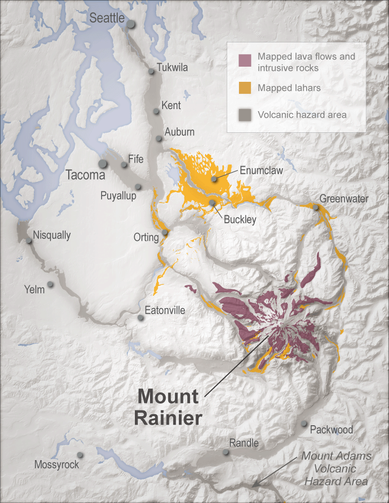
Osceola and Electron Mudflows
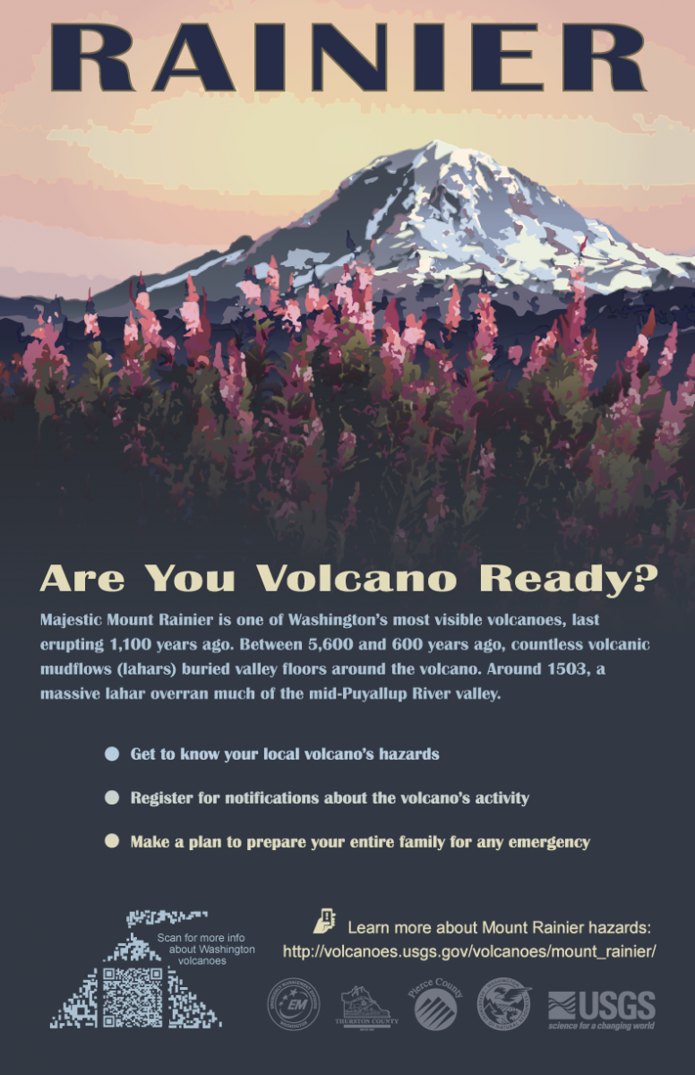
5,600 years ago, a massive debris avalanche, called the Osceola Mudflow, poured down from the summit of Mount Rainier, picking up sediment and anything else in its path as it traveled down the White River valley and into the Puget Sound. The mudflow filled valleys with ~400 feet of sediment and moved at speeds of 40 to 50 miles an hour. Following the Osceola Mudflow, many smaller volcanic eruptions and lahars occurred as the volcano continued to show signs of unrest.
The last major mudflow, called the Electron Mudflow, began as a part of a crater collapse and traveled down the Puyallup River into Sumner in ~1502.It is estimated that Mount Rainier has generated about 60 of these large lahars in the last 10,000 years. Many of the communities between Mount Rainier and the Puget Sound are built right on top of these deposits.
Links
Simplified
Hazard MapMore Info
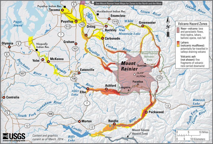
Volcanic Hazards from Mount Rainier
Living With a Volcano in Your Backyard
Digital Data for Volcanic Hazards from Mount RainierLocal Resources

-
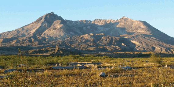
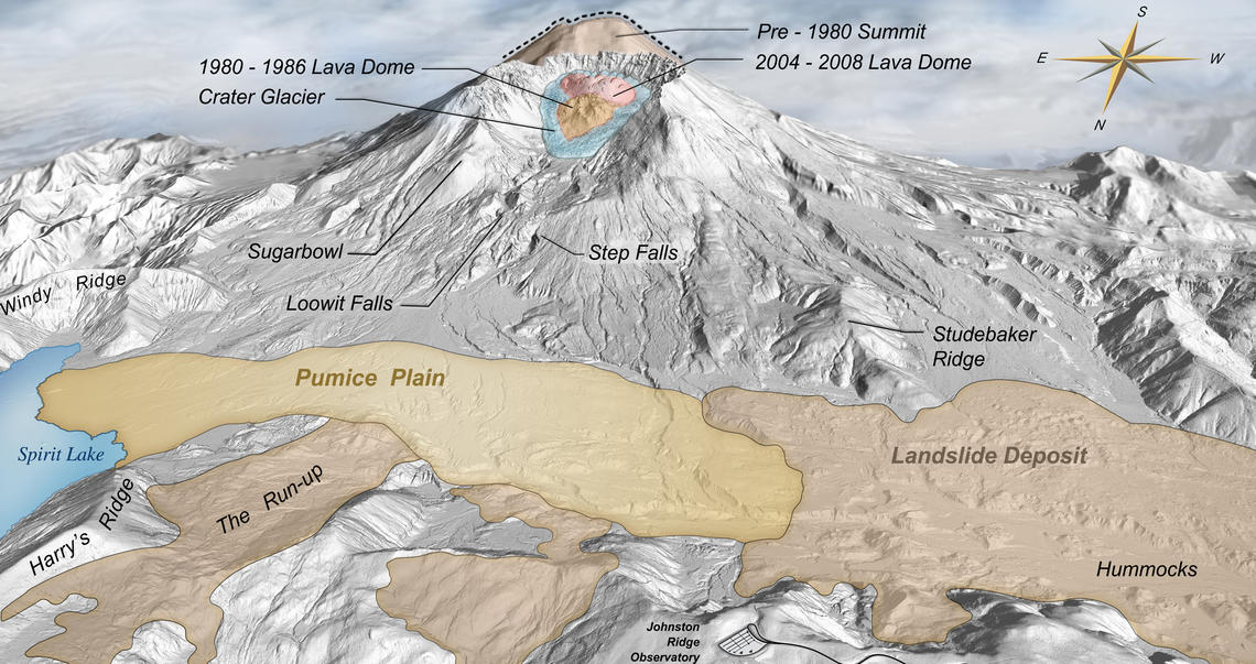
Pre-eruption profile of Mount St. Helens.
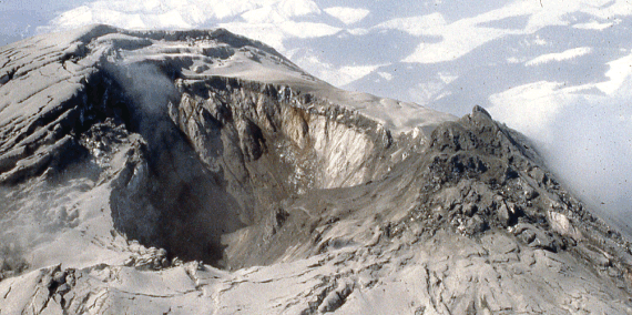
Pre-eruption crater development on the summit of Mount St. Helens.
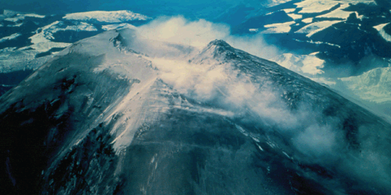
Bulge in north flank at the summit of Mount St. Helens
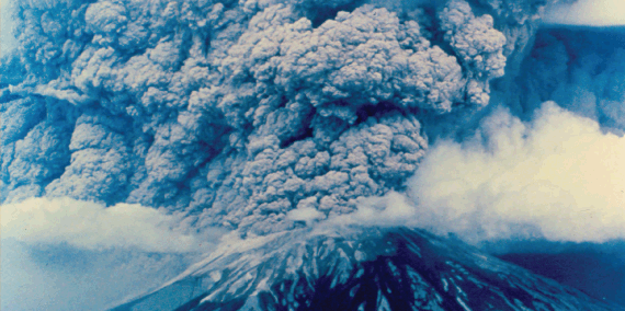
May 18, 1980.
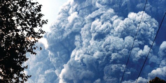
Ash cloud
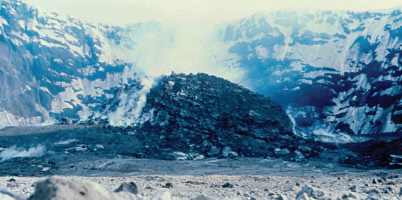
Dome building within summit crater of Mount St. Helens, 1981.
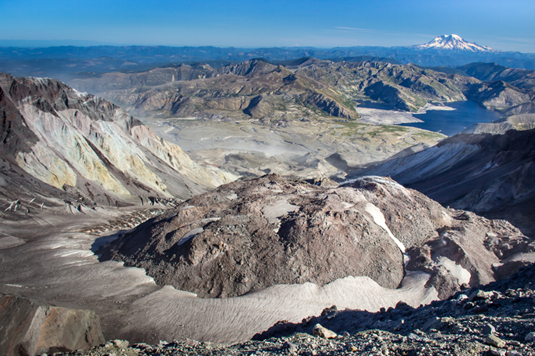
Mount St. Helens breach zone viewed from the Pumice Plain, 2012.
Geology
Mount St. Helens produces dacitic to andesitic lava flows, pumice, and lahars (volcanic mudflows). Like Glacier Peak, the composition of its magma makes it erupt more explosively than other Cascade volcanoes that erupt andesitic lava.
Eruption and Lahar History
Mount St. Helens was formed from four eruptive stages starting ~275,000 years ago, and intermittent eruptions occur to this day. During one such eruption around 2,000 years ago, lava flowed down the side of the volcano in streams. One such stream formed the Ape Caves, a spectacular 13,042-foot-long lava tube on the southeastern flank of the volcano.

1980 Eruption
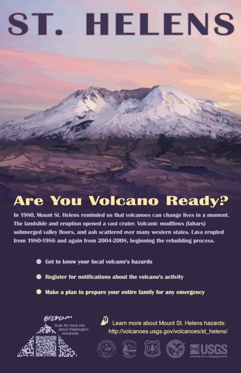
From March 16 to May 18 in 1980, a series of earthquakes, steam explosions, and small eruptions at the summit signaled a new eruptive phase of the volcano. By mid-April of 1980, a large bulge of new volcanic material had formed on the north flank of the mountain and moved outward at an average rate of ~5 feet per day.
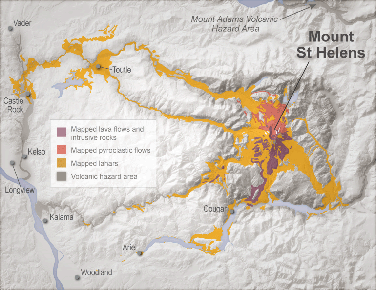
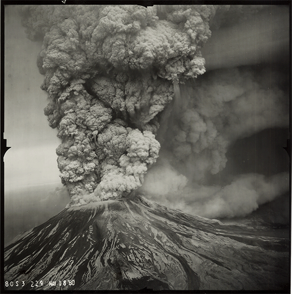
On May 18th, the cataclysmic eruption was triggered by a magnitude 5.1 earthquake. The bulge collapsed in a series of three massive slide blocks. This bulge collapse generated a chain reaction, starting with the largest avalanche in recorded history (0.6 cubic miles of material, reaching speeds of 60 miles per hour). The removal of this material decreased the pressure holding back the magma and caused the sudden release of gas, large rocks, and smaller particles to move across the landscape and destroyed most vegetation at an astounding speed of 650 miles per hour. This initial blast caused major lahar flows, pyroclastic flows, and an ash eruption that formed a eruption column that grew to 12 miles high and 45 miles across.
In addition to ash, pyroclastic flows and lahars traveled swiftly across the Pumice Plain and down the North Fork Toutle and Cowlitz Rivers, destroying houses and bridges along the way.
Footage of the 1980 eruption and lateral blast
2004 Dome Building
In September of 2004, earthquake swarms were observed along with minor explosions and lava dome growth in the summit crater. For the next 3+ years, lava continued to build up in the crater and generated a lava dome that grew to a height of 1,500 feet. This activity continued steadily until late January of 2008.

Lidar imagery of dome building at the summit of Mount St. Helens. Imagery from 2002 to November of 2004.Time-lapse images of Mount St. Helens dome growth (2004–2008).
Mount St. Helens is located along a 65-mile-long zone of intense earthquake activity called the St. Helens seismic zone. Many small to moderate (up to 5.5) magnitude earthquakes occur in this area. Geologists monitor the earthquake activity very closely to look for signals of another eruption.
Links
Simplified
Hazard MapMore Info
Volcanic-Hazard Zonation for Mount St. Helens Local Resources
-
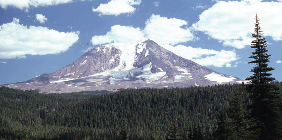
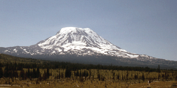
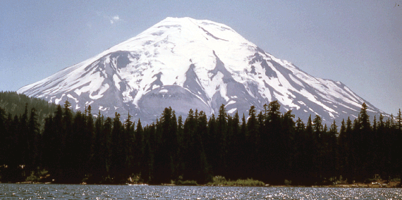
Geology
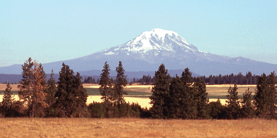
Mount Adams is volumetrically the largest volcano in the Pacific Northwest. It is actually a cluster of volcanic vents that erupted andesitic lava from the vent cluster rather than a single vent. The Mount Adams system is one of the youngest in the Cascade Range and is situated further inland than most Cascade volcanoes.
Eruption and Lahar History
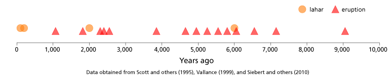
There have been no historical eruptions in the Mount Adams volcanic field. The volcanic center first erupted between 520,000 and 500,000 years ago, and continued up to about 1,000 years ago. However, there were a series of debris avalanches and lahars between ~600 and 300 years ago.
Hydrothermal alteration is present on the main cone as well as at numerous locations along the slope. Fumarole activity was reported at the summit from miners trying to extract sulfur from the crater in the 1930s, but later reconnaissance trips did not reveal any fumaroles—only the faint smell of sulfur.
Links
Simplified
Hazard MapMore Info
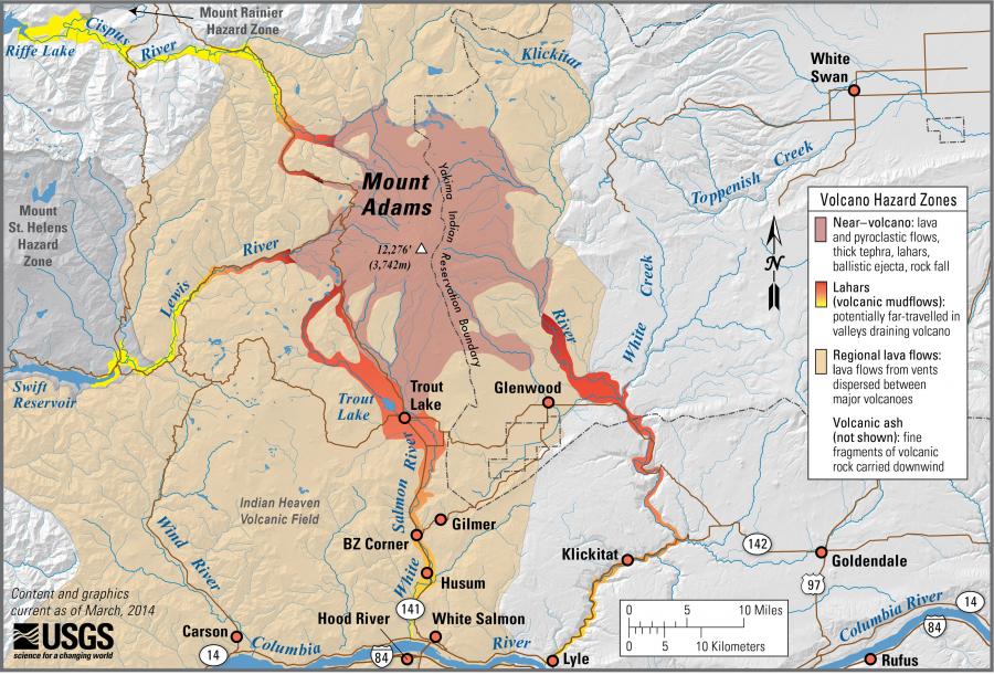
Volcano Hazards in the Mount Adams Region Local Resources


Volcanic hazards
- Who is at risk?
- Hazard types
- Monitoring
-
Who is at Risk?
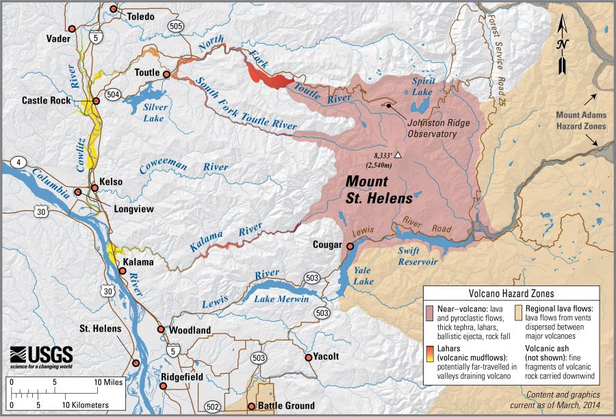
Residents throughout the state of Washington are at risk of volcanic hazards. There are active volcanoes in Washington and in the rest of the Pacific Northwest. These volcanoes tend to erupt explosively and can cause significant damage both near and far. High-speed flows of hot ash and rock, lava flows, and landslides can destroy homes and infrastructure within ~10 miles of the eruption. Enormous mudflows of ash, debris, and melted ice—called lahars—can devastate low-lying areas more than 50 miles away.
Know your risk! Learn what volcanic hazards exist near your home, place of work, or where you recreate.
Volcano Hazard Maps
Click the icons below to see the USGS simplified volcanic hazard zone maps for communities around and downstream of our major stratovolcanoes.
Volcano
Simplified
Hazard MapMore Info
Mount Baker
Potential Volcanic Hazards from Future Activity at Mount BakerGlacier Peak Volcanic-Hazard Zonation for Glacier Peak Mount Rainier Volcanic Hazards from Mount Rainier
Living With a Volcano in Your Backyard
Digital Data for Volcanic Hazards from Mount RainierMount Adams Volcano Hazards in the Mount Adams Region Mount St. Helens Volcanic-Hazard Zonation for Mount St. Helens Natural hazards interactive map showing information relating to volcanic hazards—information displayed on the map was modified from USGS simplified volcanic hazards maps, listed below. 
-
Types of Volcanic Hazards
There are five main types of volcanic hazards. Most of these hazards are associated with eruptions, but some, such as lahars, landslides, and burps of volcanic gases can occur at any time.
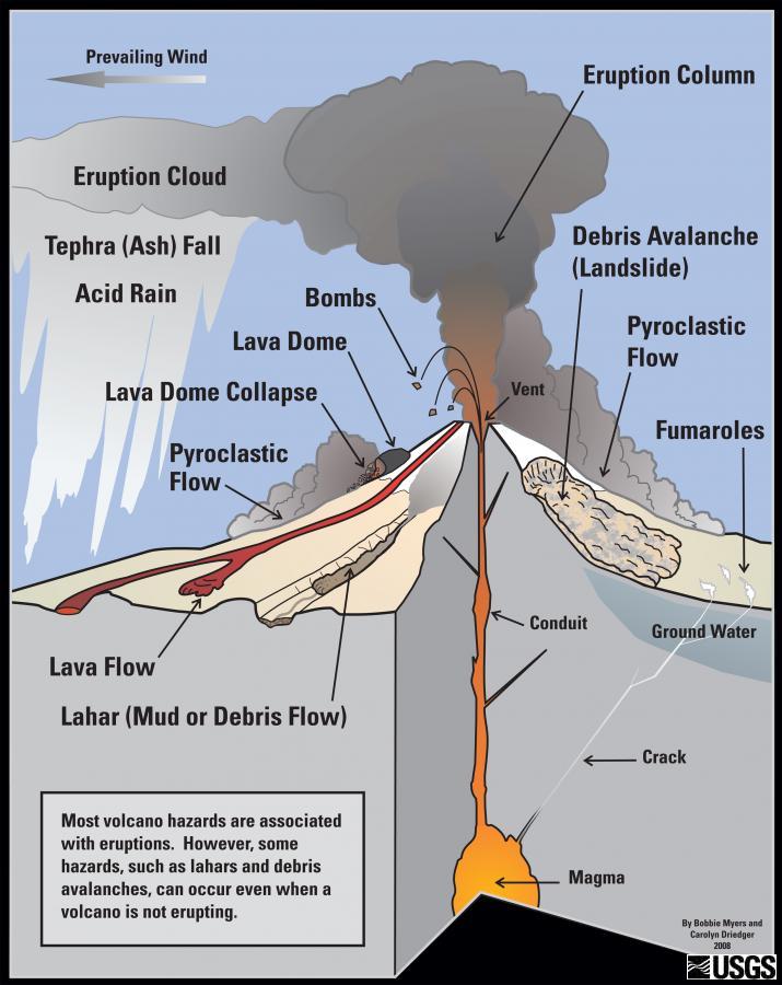
Eruption Columns and Clouds
When a volcano erupts, the blast sends gas and pieces of molten rock into the air. Lighter pieces, such as volcanic glass, minerals, and ash can rise high into the air and form a massive cloud called an eruption column. The larger pieces—called volcanic bombs—usually fall quickly to the ground with a few miles of the volcanic vent. All of these pieces of ash, bombs, and rock fragments produced during the eruption are known as tephra.
When eruption columns become large, they pose a serious hazard to health and aviation. The small particles of dust, rock, and volcanic glass—called ash—can be inhaled and cause lung damage. Ash is also damaging to airplanes if they fly through the ash cloud.
Eruption columns and ash clouds can become enormous and extend for hundreds of miles. The 1980 eruption of Mount St. Helens covered over 22,000 square miles with ash. This is considered to be a relatively small volcanic eruption. Larger eruptions, such as the 1883 eruption of Krakatoa in the south Pacific, produced enough ash to slightly lower the temperature of the entire earth for several years.
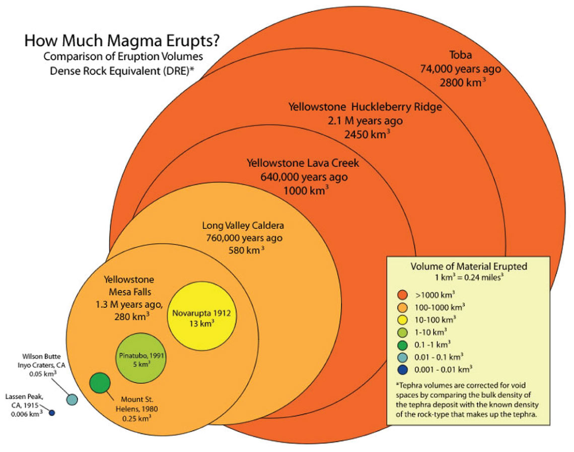
This diagram shows the sizes of a few volcanic eruptions. Smaller eruptions are much more common than larger ones. Diagram from the U.S. Geological Survey at http://volcanoes.usgs.gov/images/pglossary/eruptionsize.php.
Lava Flows and Domes
Molten rock that reaches the Earth's surface is called lava. Lavas such as basalt usually have low viscosity (are not very sticky), move very quickly downhill, and can travel great distances. Other types of lava like rhyolite have high viscosity (are sticky), move very slowly, and cannot travel very far. Lava flows are like a molten river that travels away from the volcanic vent.
Many volcanoes in the Cascade Range can erupt different types of lavas. For example, the Ape Caves near Mount St. Helens were created about 2,000 years ago by low-viscosity basalt that travelled many miles from the vent. Later, during the 1980 eruption, Mount St. Helens created a high-viscosity dacite dome over 1,000 feet tall.
Pyroclastic Flows
A pyroclastic flow is a very dangerous and fast-moving mixture of ash, rock, and gas. The root word 'pyro' means fire and 'clastic' means rock. These flows can reach temperatures of more than 1,500°F and reach speeds of 100–150 miles per hour. They often occur as hot ash and rock move down the slope of the volcano, or as a result of volcanic collapse during an eruption.
Pyroclastic flows will destroy nearly everything in their path. During the 1980 eruption of Mount St. Helens, pyroclastic flows destroyed nearly 230 square miles of forest. Trees 6 feet across were knocked down like twigs over 15 miles from the volcano.
Lahars
When enough water mixes with loose volcanic ash and rock on the side of a volcano, the mixture flows downhill and forms a lahar, a volcanic mudflow. In Washington, these mudflows can travel more than 50 miles from the volcano (sometimes reaching the Pacific Ocean!) at speeds up to 120 miles per hour. Some lahars can contain so much solid material that they look more like rivers of concrete.
Lahar in Semeru, Indonesia (2003).
Lahars can occur at almost any time and do not need a volcanic eruption. The water that forms lahars can come from snow and ice that were melted by heat from the volcano or from hot pyroclastic flows. The water can also come from intense rain events.
Lahars have typically been the deadliest volcanic hazard because they can happen at any time and affect people far downstream of the volcano.
Volcanic Landslides
Landslides and debris avalanches can occur on the slopes of volcanoes at any time. Because volcanoes are built of layers of ash and rock, their slopes can be relatively loose and weak. Groundwater and the circulation of hot acidic water from the volcano can alter minerals and make the rocks even weaker. Strong ground shaking during an earthquake, a volcanic eruption, or simply heavy rain or melting snow can trigger landslides on volcanoes.
Landslides can also occur during an eruption if a part of the volcano collapses. For example, part of Mount Shasta in northern California collapsed about 300,000 years ago and created a giant landslide over 30 miles long. The deposits of this landslide are where the cities of Weed and Yreka are now built.
Volcanic Gas
Volcanoes release gas both during eruptions and between eruptions. During eruptions this release can be very explosive and is often what propels the ash and rock into the air. As magma is formed deep in the earth, it contains small amounts of gas under very high pressure. As the magma moves towards the surface, the gases try to expand but may not be able to if the magma is very thick (viscous). When the volcano erupts, it is like opening a soda can that has been shaken up!
Between eruptions, much of the gas a volcano creates is steam. This steam is made when groundwater interacts with the hot interior of the volcano. The steam rises through cracks and can eventually reach the surface. At the surface it can form fumaroles, mud pots, or hot springs. The rising steam can also melt snow or ice, potentially causing lahars or landslides.
In addition to steam, volcanoes can also release more dangerous gas, such as carbon dioxide, sulfur dioxide, hydrogen sulfide, hydrogen, and fluorine. These gases can react with water in the air to create acid rain. Heavy gas, such as carbon dioxide, can be trapped in low-lying areas and suffocate animals or people.
-
Monitoring and Forecasting Volcanic Eruptions
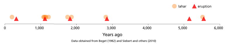
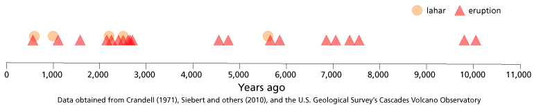
In the Cascade Range, volcanoes have been erupting for millions of years. During the past 4,000 years, eruptions have occurred at an average rate of about two per century. We know that all of the Cascade Range volcanoes are active and have had major eruptions in the recent past, but many lie dormant for centuries. It is certain that they will erupt again, but we cannot forecast exactly which one will erupt next.

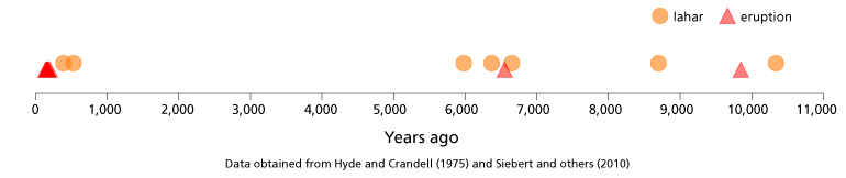
This chart shows five volcanoes in Washington and time lines for each showing the ages of their recent eruptions and significant lahars. Click on the chart to enlarge it.
Monitoring
Volcanoes are part of a complex geologic system that operates on time scales of tens to thousands of years. Our best defense against volcanic hazards is through careful monitoring. Importantly, not all volcanic activity is a warning sign that an eruption may occur. Sometimes, volcanic earthquakes or other indicators are simply reminders that volcanoes are constantly changing. Some volcanoes have erupted without much warning while others provided ample warning. And of course, there are volcanic hazards that aren't associated with eruptions! Lahars and toxic steam emissions can occur regardless of an impending eruption.
Volcano scientists utilize a variety of tools to assess volcanic hazards. Some volcanologists hike around and collect rocks or make geologic maps while others study volcanoes using experiments in a lab or simulations on a computer. Read each section below to learn about some of these tools.
Seismology
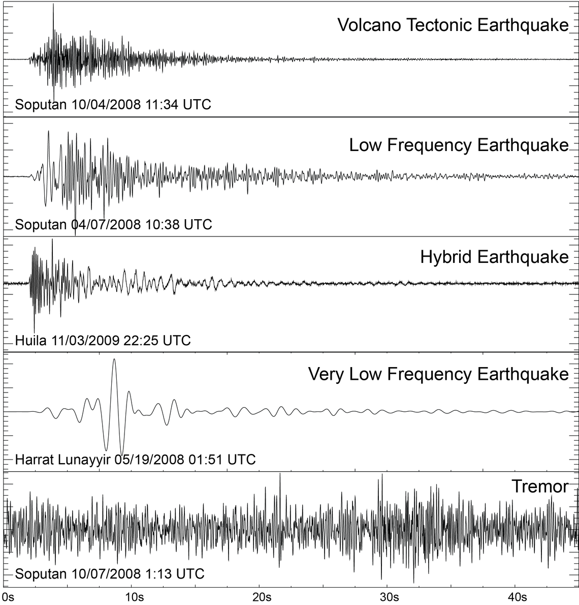
Different types of volcanic activity produce distinct signals that can be seen on a seismogram. Volcanic explosions, volcanic earthquakes, and migrating magma or fluids can create seismic signals. Image from the U.S. Geological Survey.Large numbers (10s to 1,000s) of small earthquakes sometimes happen right beneath a volcano as magma moves through the volcano's interior plumbing.
Geologists at the Pacific Northwest Seismic Network and Cascade Volcano Observatory use the increase in earthquakes to continuously monitor the volcanoes of the Pacific Northwest. When there is enough data to cause concern, scientists deploy mobile monitoring instruments to more closely watch the volcano. Close monitoring of Mount St. Helens enabled evacuation notices to be issued prior to the major eruption.
Monitor the volcanoes yourself at the Cascade Volcano Observatory and the Pacific Northwest Seismic Network.
Remote sensing
Geoscientists utilize sensors on aircraft, unmanned aerial vehicles, and satellites to track changes to volcano behavior. Thermal remote sensing detects temperature changes that might indicate lava or hot gas is nearing the surface. Other instruments measure gas content from volcanoes, usually focusing on SO2. Remote sensing techniques such as radar or photogrammetry measure land-level changes around the volcano, such as uplift or subsidence, that can indicate magma, gas, or liquid movements. Remote sensing is especially useful for providing images over large areas and providing access to places that are not easy to get to.
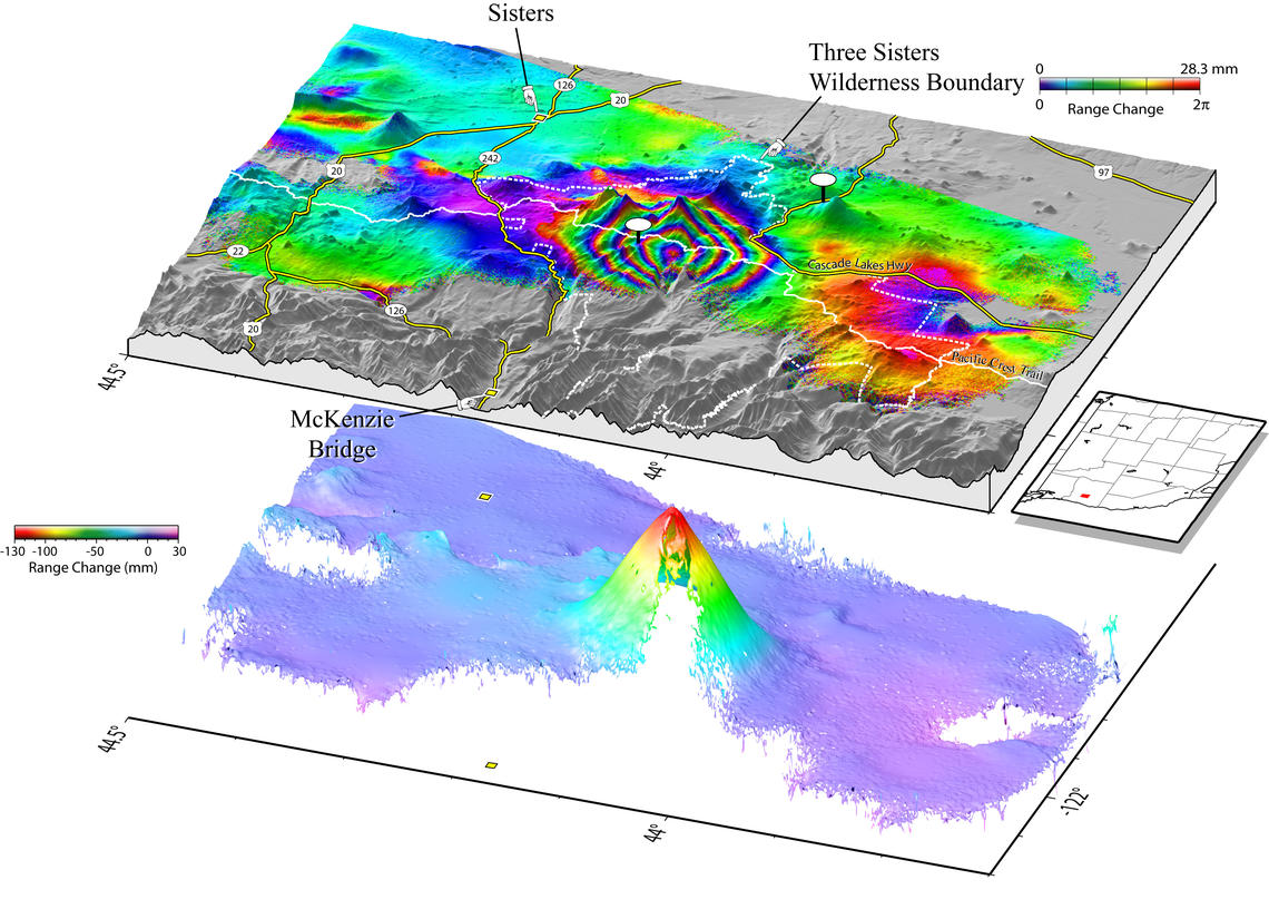
Radar measures when the ground moves, which can happen often near a volcano. Image from the U.S. Geological Survey.
Geodesy
Geodesy is the study of land-level changes, and it can be measured from the ground as well as from space. GPS stations, tiltmeters, and leveling devices can detect land-level changes to specific locations where these instruments are deployed. Lidar is a technique that measures topography with great accuracy and reveals topographic changes in the ground over time.
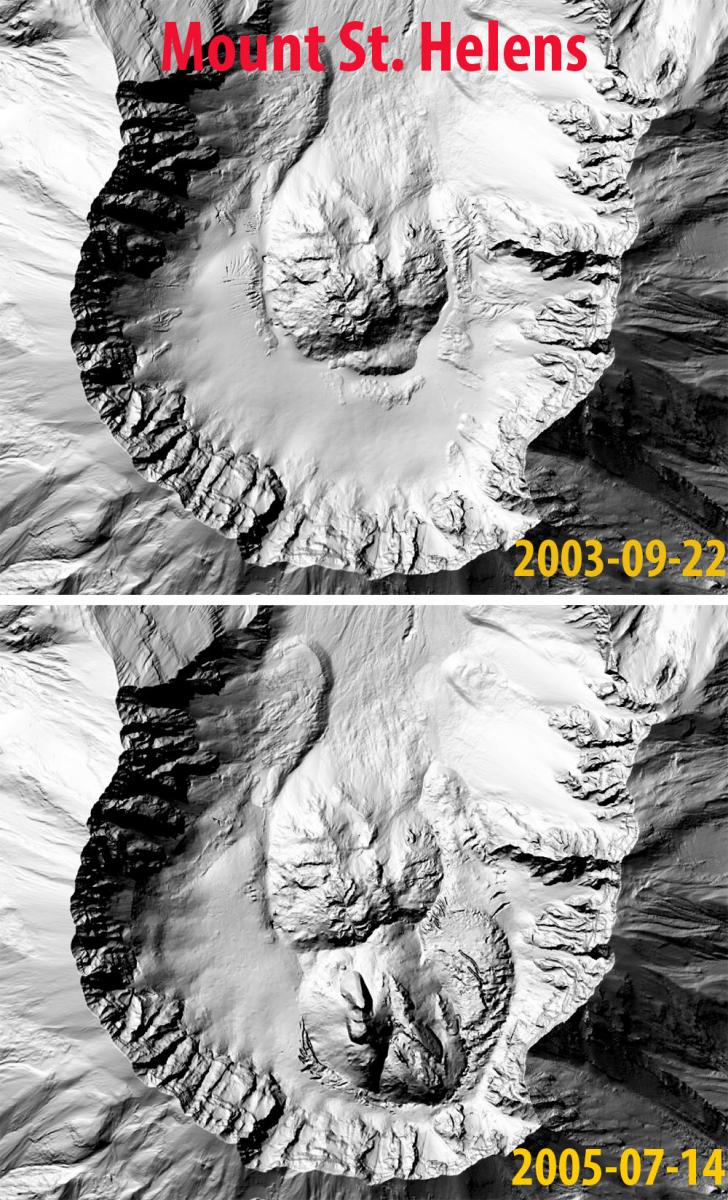
Lidar provides high-precision measurements of the earth, here demonstrating how the crater of Mount St. Helens volcano changed over a few years. Image from the U.S. Geological Survey.
Geochemistry
Geochemists use remote sensing as well as ground-based instrumentation to measure gas and water content from a volcano. The types of gas, and the amount of gases (including water) indicate the type of magma. Scientists also take rock samples and analyze their contents in a lab to learn more about processes occurring within the magma chamber.
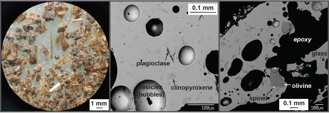
A microscopic image of tephra from Kilauea (far left image), also viewed under a scanning electron microscope (middle and right images). Images from the U.S. Geological Survey.
Geophysics
Geophysicists also use remote sensing and ground-based instruments to study volcanoes. Geophysicists use methods such as gravity, magnetotellurics, and electromagnetic measurement tools to observe density changes, image the size of lava tubes, and measure magma movements underground.
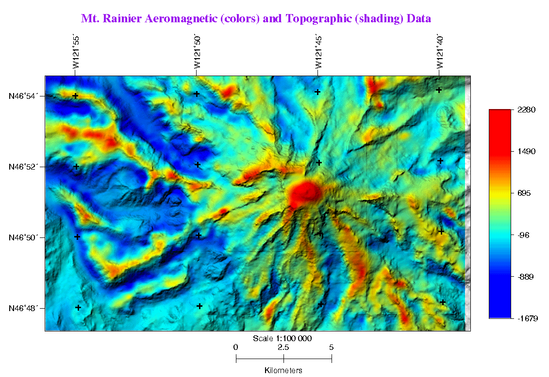
An aeromagnetic image over Mount Rainier from 1996. The red areas correspond to magnetic, normally-magnetized, fresh dacitic-andesitic rocks not demagnetized by weathering or hydrothermal activity. Blue colors represent lows caused by topography and demagnetized volcanic rock. Image from the U.S. Geological Survey.
Thermal measurements
Scientists can also measure temperature changes to learn about volcanic activity. Some volcanoes have lakes of water on them that might change temperature before an eruption. Other volcanoes might have lakes of lava where similar temperature changes can occur. Additionally, active lava flows can be easily tracked with thermal sensors.
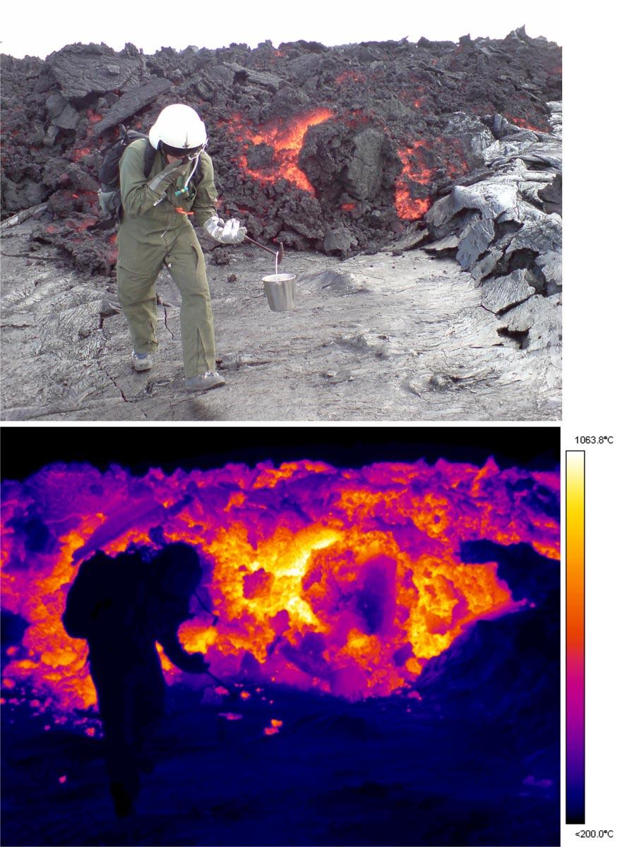
A geologist collects a sample of lava in Hawaii. The bottom image is a thermal image of the top one which shows the extereme temperatures in the lava flow. Image from the U.S. Geological Survey.
Acoustic signals
Measuring sound waves and patterns in these waves is another way to study and monitor volcanoes. Acoustic monitoring is used for lahar warning systems and for detecting the onset of an eruption at a remote volcano.
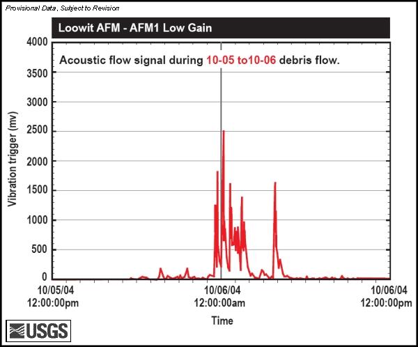
Acoustic signal of a lahar at Mount St. Helens in 2004. Image from the U.S. Geological Survey.
Computer models
Scientists use computer models to simulate volcanic behavior and gain intuition about a volcano's history and future. For example, scientists can create simulations of volcanic ash spread during an eruption to postpone air traffic that might be impacted by the ash.
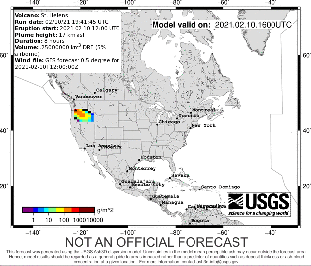
A model simulation showing the path of the ash cloud were the 1980 Mount St. Helens eruption to happen on February 10, 2021. Animation from the U.S. Geological Survey.
Mapping
Geologists also create and use geologic maps showing extents of past lava flows and ash falls to understand the size of past eruptions at a volcano. This also demonstrates the typical volcanic hazards that can be expected from a volcano and provides an estimate for the frequency of eruptions and the size of future eruptions.
Lidar image of Mount St. Helens overlain with mapped landslide deposits (brown) and ash fall deposits (yellow). Image from the U.S. Geological Survey.
Evacuation and Preparation
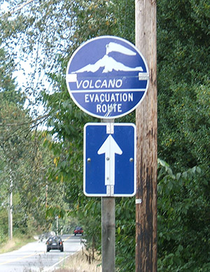
Volcanic eruptions and lahars are frightening natural disasters. It is important to prepare ahead of time.
The eruption of Mount St. Helens on May 18, 1980 killed 57 people, destroyed 27 bridges and almost 200 homes, and caused disruption for thousands of people. You can minimize damage and loss of life by being prepared for a volcanic emergency. One of the most important things you can do is learn about your risks.
The following information is synthesized from the Cascade Volcano Observatory, Washington Emergency Management Division, and Ready.gov web sites.
More information about volcanic hazards and preparedness can be found in the Volcano Hazard Information Map
Before an Eruption
- Learn about your risks—Know the danger and hazards you face at home, at work, and where you relax, adventure, or travel.
- Plan ahead. Have emergency supplies, food, and water stored.
- Plan an evacuation route away from streams that may carry lahars or landslide debris.
- Make sure your emergency provisions contain a pair of goggles and disposable breathing masks for ash and dust.
- Make a family emergency plan so that you know how to contact your family members in case of an emergency.
- Stay informed: Listen to media outlets for warnings and evacuations. Listen for All Hazard Alert Broadcast sirens that warn of lahars. Check out the Volcano Notification Service to subscribe to alerts about specific volcanoes.
- Ask local and state emergency offices and schools about their response plans. Be prepared to follow official guidance.
Be informed. Make a plan. Build a kit. Educate and protect your family, neighbors, and friends.
During an Eruption
- Follow evacuation orders issued by authorities. Evacuate immediately from an erupting volcano!
- Be aware that lahars and other types of landslides or debris flows can travel great distances from the volcano. Avoid river valleys and other low-lying areas that may be prone to these hazards.
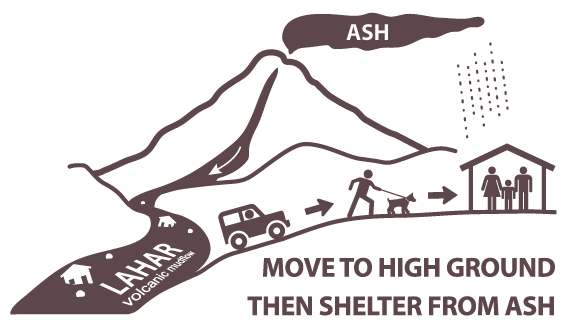
- If you are in a lahar hazard zone and become aware of an oncoming lahar, get to high ground and then shelter in place. If there are signs for evacuation routes, follow them.
- Stay informed: Watch and/or listen for additional information.
- Listen for All Hazard Alert Broadcast sirens that warn of lahars.
- Do your part to remain safe and help others in need.
If There is Ashfall...
Protect your lungs!
Volcanic ash is made of microscopic shards of glass and other fine-grained material. Ash can can cause significant damage to animals, including significant damage to lungs or asphyxiation if inhaled.
- If there is falling ash and you cannot evacuate, remain indoors with doors, windows, and ventilation systems closed until the ash settles.
- Help infants, the elderly, and those with respiratory conditions.
- Wear a respirator, face mask, or a use a damp cloth across your mouth to protect your lungs.
- Use goggles, and wear eyeglasses instead of contact lenses.
- Avoid driving in heavy ash fall unless absolutely required. If you must drive, reduce your speed significantly.
- Avoid operating engines of any kind. Ash can clog engines, damage parts, and stall vehicles.
- Wear long-sleeved shirts and long pants.
- Keep roofs free of ash in excess of 4 inches.
- Limit outdoor activity. Remove outdoor clothing before entering a building.
- Check to ensure that ash does not contaminate your water. If it does, use a different source, such as bottled water.
- For more information about ash fall, check out the USGS Volcanic Ash website.
After an Eruption
- Go to a designated public shelter or evacuation area if you have been told to evacuate or you feel it is unsafe to remain in your home. Text SHELTER + your ZIP code to 43362 (4FEMA) to find the nearest shelter in your area (example: shelter 98506)
- Stay informed: Watch and/or listen for additional information. Listen to NOAA Weather Radio, watch TV, listen to the radio, or check the internet for official instructions and information.
- Do not approach the eruption area.
- Be prepared to stay indoors and avoid downwind areas.
- Be aware of lahars and landslides. These hazards can occur long after the main eruption.
Volcano Hazard Information Map
Click on the volcano icons below to find lots more online resources to inform you about emergency preparedness, volcanic hazards, emergency notification systems, and evacuation plans.
Understand volcanoes
- The Ring of Fire
- What is a Volcano?
- Types of Volcanoes
- Types of Lavas
-
Volcanoes usually form at the boundaries of tectonic plates (where the Earth’s crust moves apart, collides, or slides by another plate). The Ring of Fire is a horseshoe-shaped “ring” about 25,000 miles long that circles the Pacific Ocean. It is called the Ring of Fire because that is where most of Earth’s volcanoes are found.
The Ring of Fire is also a Johnny Cash song to which geologists love to make their own silly volcano parodies.
There are 452 volcanoes in the Ring of Fire, and it is home to 75% of the world’s volcanoes and about 90% of the world’s earthquakes.
Check out the Storymap below to learn more about some of the major volcanoes in the western United States that are a part of it:
3D Story Map about the Ring of Fire, by Esri. View in fullscreen.
-
A volcano is an opening in the surface of a planet (or moon) that allows hot material to escape from an area of magma storage below the surface, commonly called a magma chamber. The location where the magma erupts is called the volcanic vent. When the magma breaches the surface of Earth's crust, the volcano erupts, and the erupted magma is referred to as lava. Over time, the erupted materials pile up to form the tall, broad slopes of the volcano. The magma or lava is itself a combination of molten rock, crystals, and gases, and it is this composition that influences the style of eruption and the type of volcano. Eruptions can be explosive, sending hot mixtures of ash, gas, and rock high into the sky. Eruptions can also be calmer, spurting out steam or sending minor amounts of lava down the slope.
But where does the magma come from? Magma is formed in the mantle of the Earth, the layer of the earth just below the crust. The earth has three main layers. If you think of the Earth like an egg, the egg white inside is like the mantle, and the egg yolk is like the core. The mantle is made of solid rock that is very hot, and it actually moves very slowly. The rock in the mantle cycles up and down in a circular motion called convection. This is similar to the way a pot of boiling water heats up on your stove, and this is also a process that regularly occurs within Earth's atmosphere and oceans.
The shell of the egg is like Earth's crust, which is broken into pieces like a jigsaw puzzle. These pieces of crust along with a small portion of the mantle below them are relatively rigid and brittle, and are referred to as tectonic plates. Tectonic plates float on the hot mantle beneath. (The brittle plates are known to geologists as lithosphere, and the more malleable/ductile mantle below is known as the asthenosphere). Once mantle rock melts, the magma has to move through the mantle and through the crust to erupt at a volcano. There are three ways the magma can make it to the surface:
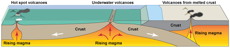
Subduction zones, mid-ocean ridges, and hot spots. Image modified from Nasa SpacePlace.
1) Subduction zones—When tectonic plates move towards each each other at convergent plate boundaries, one of the tectonic plates is pushed under the other, and dives into the mantle. This process is called subduction. The 'diving' tectonic plate is subjected to very high temperatures and pressures as it is forced downward, releasing water from the plate that melts the surrounding mantle and makes magma. Molten magma is less dense than the rest of the mantle (think of what happens when you mix oil and water; the oil always pushes to be on top of the water because the oil is less dense) so it rises to the surface and forms a volcano. Many volcanoes in Washington were built in this way.
2) Mid-Ocean Ridges—When tectonic plates move in opposite directions away from each other at divergent plate boundaries, an opening forms at the surface. This opening releases pressure on the mantle below, allowing it to melt and form magma. Once again, the magma is less dense than its surroundings so it rises to fill the space. This typically happens in oceanic crust underwater and forms long ridges of underwater volcanoes.
3) Hot Spots—The third way that volcanoes can form is from a hot spot inside the Earth. Scientists are still figuring out exactly why hot spots happen where they do, but the basic idea is that a portion of molten magma rises and pushes its way through the middle of a tectonic plate to reach the surface. Yellowstone and the Hawaiian islands are two famous examples of hot spot volcanoes.
-
Are all volcanoes alike? While many people think of a volcano as a cone-shaped mountain that spits red hot lava and has a plume of ash, there are in fact multiple types of volcanoes. Many of these types of volcanoes (or remnants of them) can be found in Washington state.
The shape, size, and lifespan of a volcano depends on its location (under the ocean, at a convergent plate boundary, a hot spot, etc.) and the chemistry and composition of the magma that erupts from it. In particular, the amount of water vapor (dihydrogen monoxide, a.k.a. H2O) and other gases and the amount of silica (silicon dioxide, SO2) greatly influence the type of magma and the type of eruption. Generally, magmas that contain more silica will be stickier (more viscous), and more likely to flow slowly and erupt explosively. Magma is also influenced by its location; magmas that push through continental versus oceanic crust will mix in with different types of rocks on their journey to the surface. The chemistry of the magma determines whether the volcano erupts either explosively or non-explosively, and the style of eruption also affects the overall shape of the volcano.
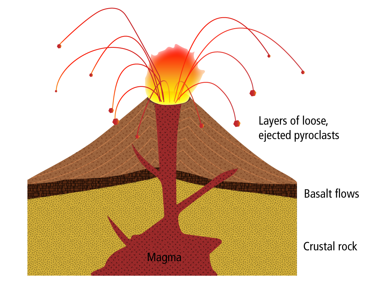
Cinder Cones
Cinder cones are steep, cone-shaped hills made up of cooled, air-filled lava called cinder or scoria that was ejected from a single vent. They usually erupt lavas ranging from basalt to andesite. Cinder cones are commonly found near shield volcanoes, stratovolcanoes, or calderas, and are the most common type of volcano on Earth. They are relatively small, generally no taller than a few hundred feet. Some cinder cones only erupt once while others may erupt many times, and eruptions can last days or even decades! Parícutin cinder volcano in Mexico grew from an eruption that lasted from 1943 to 1952.

Layers and eruptive products of a typical cinder cone volcano. Click the image to enlarge it.
When there is a high gas content in the magma, more explosive eruptions occur, ejecting jagged, fragmented pieces of rock. Gases trapped within magma stored underground will expand when the magma migrates toward the surface for an eruption. As the gases expand, they exert pressure that can cause the magma to break into tiny pieces and explode. During the eruption, these tiny rock fragments build up around the mouth of the volcano and construct a cone over long periods of time. Cinder cone volcanoes are formed entirely of rock fragments and rocks with holes (these holes are known as vesicles). Cinder cones can also produce fire fountains, which are vertical fountains of lava. In addition, lava flows may also flow out from the base of the cone.
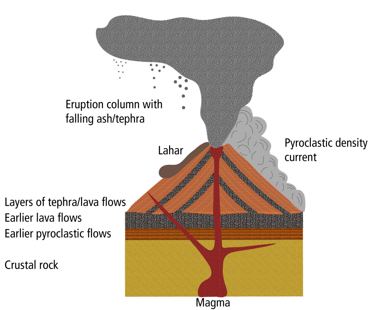
Composite Volcanoes/Stratovolcanoes
Composite volcanoes or stratovolcanoes are typically some of the world’s most beautiful and beloved mountains. Many of the well-known volcanoes in Washington, including Mount Baker, Glacier Peak, Mount Rainier, Mount Adams, and Mount St. Helens, are stratovolcanoes. These beautiful mountains are what most people think of when they picture a volcano—steep-sided, symmetrical cones that typically have a crater at the summit. Stratovolcanoes can be very tall, many are more than 14,000 feet. They are commonly found at convergent plate boundaries, such as along the edge of the Pacific Ocean within the Ring of Fire.
Stratovolcanoes are built from alternating layers of volcanic ash, lava flows, debris flows, and cinder. These volcanoes form when less fluid, stickier lavas erupt, especially andesite and dacite. These lavas usually erupt after accumulating over long periods of time in a magma chamber within continental crust. As the magma sits underground, it cools partially and crystallizes. If new magma comes into the chamber, it can re-heat the older magma. It can also heat and pull in rocks from the more solid boundary of the magma chamber. This process of new magma entering, re-heating, solidifying, and incorporating surrounding rocks is what makes stratovolcano eruptions increasingly silicic and compositionally diverse.
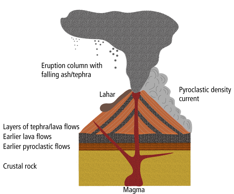
Anatomy and eruptive activity for a typical stratovolcano. Click the image to enlarge it.
These volcanoes can also be deadly when they erupt due to the gases trapped inside. The biggest hazard for people living near stratovolcanoes is not from lava, which moves slowly down the volcano, but from lahars (fast-moving volcanic mudflows) or pyroclastic flows (fast-moving mixtures of sharp particles and hot gases) that can barrel down the slopes of the volcano at incredible speeds (up to 120 miles per hour!) destroying everything in their path.
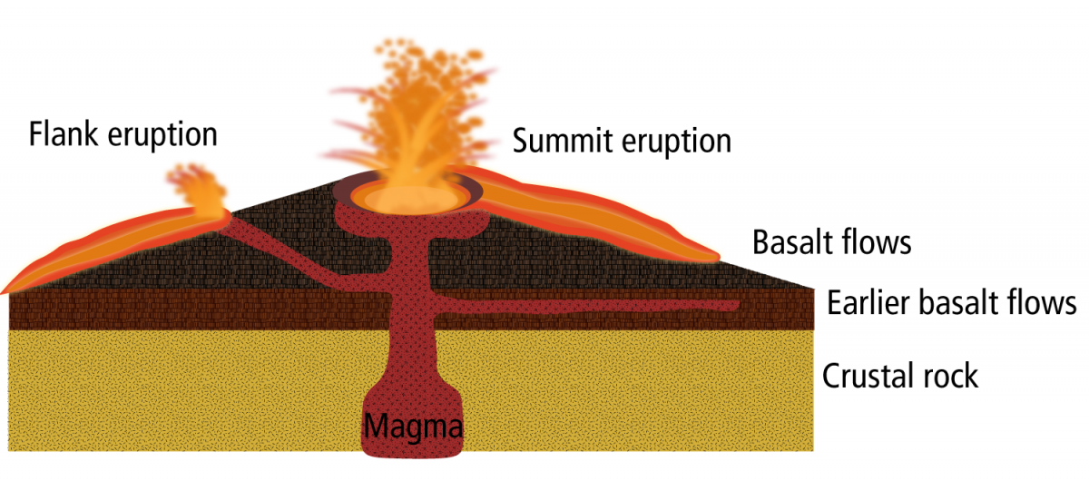
Shield Volcanoes
Shield volcanoes include some of the largest volcanoes in the world. They are called shield volcanoes because when you look at them from afar they resemble a warrior’s shield. Mauna Loa, a shield volcano on the big island of Hawaii, is one of the largest mountains on earth. It reaches more than 55,000 feet from its base and is approximately 70 miles across. However, some shield volcanoes in the Pacific Northwest are smaller than stratovolcanoes.
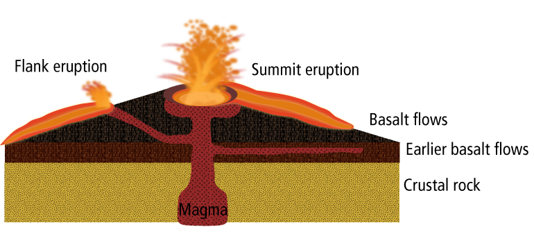
Anatomy and eruptive activity for a typical shield volcano. Click the image to enlarge it.
Shield volcanoes have shallow slopes and are made of layer upon layer of cooled lava that flowed down the slopes in all directions from a central summit vent, or group of vents. Lava can also erupt from fractures or fissures along the edges of shield volcanoes, or from non-central vents. Shield volcanoes usually erupt low-viscosity basalt that flows easily down the flanks of the volcano. Though slow-moving, usually averaging only 1 mile per hour, they can move up to 6 miles per hour on steep slopes and they cannot easily be diverted. Near communities, slow-moving lava flows can obstruct roads and burn through homes.
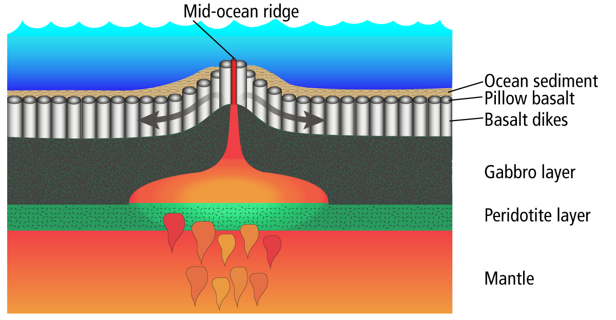
Mid-Ocean Ridge Volcanoes
Though you might not normally think about them as volcanoes, mid-ocean ridges are the largest, most extensive volcanic features on earth. They erupt large amounts of lava—in fact, more than any other type of volcano! Mid-ocean ridges are tectonic plate boundaries where pieces of oceanic crust are being pulled apart to make way for new oceanic crust. As the plates move away from each other, the space between them opens up, reducing pressure on the underlying mantle material. This allows the mantle to melt and magma rises up between the plates.
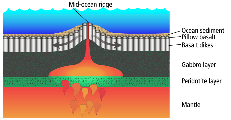
Diagram of a mid-ocean ridge volcano. Modified from Press and others (2003). Click the image to enlarge it.
As the magma rises from the mantle to the surface, it repeatedly melts and cools, leaving behind a distinctive sequence of rock types. The lowest layer includes peridotite (formed of the bright green mineral olivine) which settles to the bottom of the magma pile. Next are layers of gabbro, an intrusive igneous rock that has the same composition as basalt but cools and solidifies underground. Above that are dikes or magma pathways, essentially cooled columns of basalt. The topmost rock layer consists of pillow basalts, lavas that erupt on the surface of the ocean and make contact with ocean water, causing them to expand into pillowy shapes. These layers comprise the oceanic crust, upon which deep-sea sediments are deposited. The newly made oceanic crust spreads outward and moves away from the ridge, eventually being recycled back into the mantle at a subduction zone.
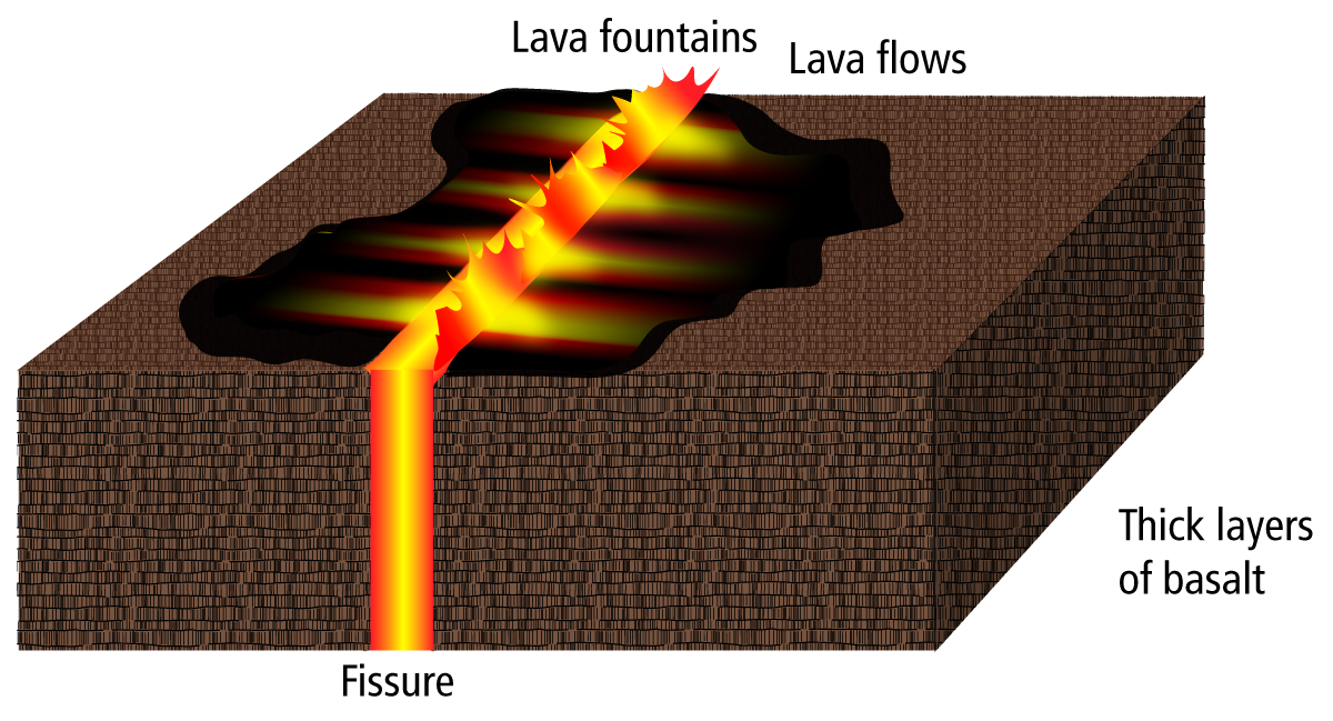
Fissure Volcanoes
Prolonged eruptions from cracks in the Earth’s surface, known as fissure eruptions, can produce very thick lava layers. The Columbia River Basalt Group (CRB) that covers southern Washington and large portions of Idaho and Oregon erupted from multiple fissures over thousands to millions of years. These lavas are a classic example of flood basalt volcanism.
Flood basalts form around the world, and the CRBs, though impressive, are not close to being the largest. In fact, the CRBs are the smallest flood basalt province on Earth, but they are widely studied because they are the youngest and best preserved example of flood basalts worldwide. Other notable flood basalt provinces are in India, known as the Deccan Traps (about 60 million years old), and in Russia and Kazakhstan, known as the Siberian Traps (about 250 million years old). The Siberian Traps are the largest flood basalts known. They cover an area the size of Western Europe and are more than 1 km thick!
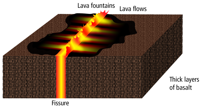
Diagram of a fissure eruption/flood basalt in action. Click the image to enlarge it.
The reason these flood basalt provinces erupt so much magma has been a long-standing research question for geologists. The leading hypothesis is that these eruptions are produced from 'mantle plumes', large upwellings of mantle material (think of a lava lamp) that rise up through the crust. When the 'head' of the plume (the broad top of the upwelling) reaches the base of the lithosphere, it generates a lot of magma. This magma then rises through the crust to erupt in these 'hotspots' as flood basalts.
These massive eruptions release large quantities of greenhouse gases, producing a poisonous atmosphere and raising temperatures on Earth. Many researchers think these events may have been partly or wholly responsible for mass extinctions. The Deccan Traps, for example, erupted around the same time that the dinosaurs went extinct, commonly known as the 'K-T' or 'P-T' extinction. The Siberian Traps may be related to the end-Permian mass extinction, during which 96 percent of marine species and 70 percent of land-based species went extinct. This was the most devastating extinction to have occurred in Earth’s history.
Caldera Volcanoes
Calderas form when a volcano erupts so much material that its magma chamber empties significantly. When this happens, there is a vacant cavity in the subsurface where the magma used to be. No longer supported, the rocks on top of the empty chamber collapse inward, forming a large collapse caldera.
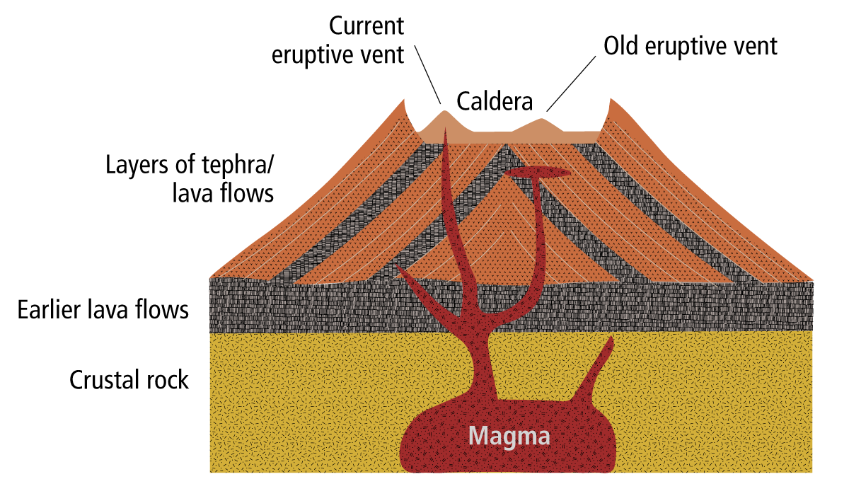
Diagram of a caldera volcano. Click the image to enlarge it.
Maar Volcanoes
Maars are volcanic craters that form when magma interacts with groundwater and generates explosions. These types of eruptions often happen only once, or they may happen multiple times within quick succession. When magma infiltrates cracks in the Earth and encounters groundwater, the hot magma causes the water to flash to steam. The heat and energy associated with this meeting produces a big explosion, ejecting steam, nearby rocks, and magma fragments, and leaving behind a crater. Over time, these craters often fill with water, making lakes.
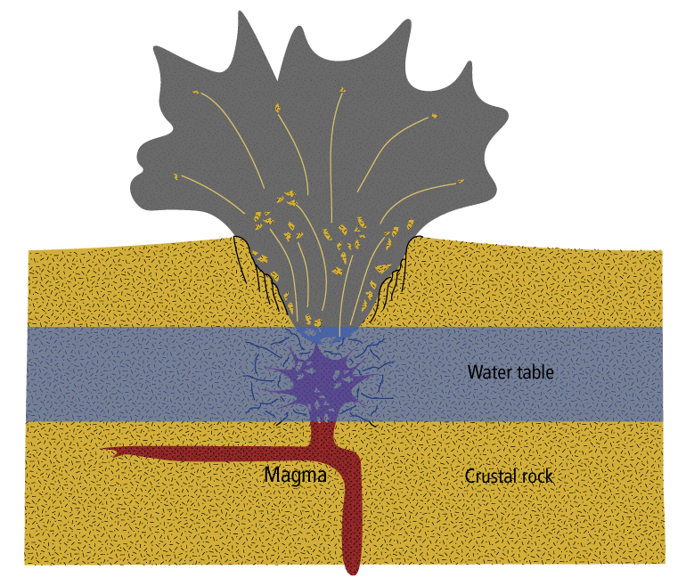
Diagram of an erupting maar volcano. Modified from T. L. Thornberry-Ehrlich in the National Park Service. Click the image to enlarge it.
-
There are many types of lavas. Some volcanoes are capable of producing multiple types of these lavas while others tend to produce the same lavas time after time. Lavas span many compositions from basalt to andesite to dacite and to rhyolite, as well as compositions inbetween. Read the sections below to learn more about the characteristics of different lavas.
Basalt
Basalt is mafic: it's dark in color, often dark gray to black, because it contains between 45 to 53 percent silica. It has a relatively low silica content relative to other lavas, meaning it can flow with ease (it has low viscosity). Because of this flowability, erupted basalt can reach distances greater than 20 km. Basalt is also primitive magma, meaning that is produced simply by the melting of rock in the mantle. Basalt contains the minerals olivine, pyroxene, and plagioclase. Basalt rock is the primary composition of the oceanic crust, of ocean island shield volcanoes like Hawaii, and of flood basalts and large igneous provinces. When it erupts, its temperature is the hottest of all lavas between 1100 and 1250 degrees Celsius. Basalt is the extrusive form of gabbro.
Basalt from Drumheller Channels, Adams County, WA. Photo by Dan Coe, WGS/DNR.
Andesite
Andesite is intermediate, often gray to light black, but contains more silica than basalt: 52 to 63 percent. Andesite rock contains the minerals plagioclase, pyroxene, and some hornblende. Andesites commonly erupt from stratovolcanoes, producing explosive eruptions. The lava flows from Mount Rainier have historically been andesite. Andesite erupts at temperatures between 900 and 1100 degrees Celsius. Andesite is the extrusive form of diorite.
Andesite from Jumbo Dome volcano near Healy, Alaska. Photo by C.E. Cameron, Alaska Volcano Observatory/U.S. Geological Survey.
Dacite
Dacite is intermediate: it's lighter in color, usually light gray, and contains 62 to 69 percent silica. Dacite cotains the minerals plagioclase and quartz with some hornblende, biotite, and pyroxene. Dacite lavas are viscous and tend to form explosive eruptions and lava domes. Dacite is often found in volcanoes near continental subduction zones, such as Mount St. Helens. Dacite is usually produced through mixing of different magmas or when a magma incorporates rock fragments from the continental crust (crustal assimilation). Dacites erupt at temperature between 800 and 1000 degrees Celsius. The intrusive equivalent of dacite is granodiorite.
Dacite from the lava dome inside the crater of Mount St. Helens volcano. Photo by Dan Coe, WGS/DNR.
Rhyolite
Rhyolite is felsic: light gray or tan to pinkish in color, and contains 69 to 80 percent silica. Rhyolite is composed of the minerals quartz, plagioclase, and sanidine, with some hornblende and biotite. The crystals in rhyolite are usually very small and hard to see (aphanitic). Rhyolite is usually erupted explosively as ash or pumice, and is associated with calderas. Some rhyolite lavas were produced by the eruption of Mount Mazama, which was the predecessor to Crater Lake in Oregon. Rhyolite is the extrusive form of granite.
Rhyolite from Novarupta volcano in Alaska. Photo by Cyrus Read, Alaska Volcano Observatory/U.S. Geolgoical Survey.

What we do
The mission of the Washington Geological Survey is to collect, develop, use, distribute, and preserve geologic information to promote the safety, health, and welfare of the citizens, protect the environment, and support the economy of Washington.
Develop hazard response plans
The Washington Geological Survey works with an inter-agency team of counties, the U.S. Geological Survey, and the Washington Emergency Management Division to develop response plans to volcanic events. This effort includes:
- Loss estimation analysis for areas near volcanoes. As of 2015, we have completed this analysis for areas near Mount Rainier.
- Loss estimation and multi-hazard analysis for all other areas near volcanoes and for all counties in Washington. These analyses are currently underway.
Work to increase public understanding
The Survey works to increase public and scientific understanding of volcanic hazards in our state through efforts such as this website, field guides, and other public outreach. We work closely with the Washington Emergency Management Division, the U.S. Geological Survey, and local counties to develop and publish educational material and information about evacuation.
Please visit our Geologic Information Portal and Geologic Hazard Maps page for the most up-to-date listing of all of our hazard maps.
|
|
|
Check out our Field Trip Guides for Mount Rainier and Mount St. Helens
|
|
|
Consider subscribing to our blog, Washington State Geology News, to receive notifications when new information is published. Also check out Ear to the Ground, published by the Department of Natural Resources.
Assist during times of emergency
The Survey is the lead science agency for the State during times of geologic emergency. During these times we assist other emergency planners and responders, such as the Washington Emergency Management Division, in making geologically sound decisions.
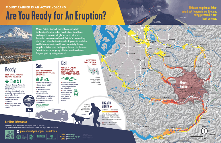
Volcano Preparedness Products
Volcanic Hazards in Washington Booklet
We have created a new booklet about volcanic hazards in Washington. Learn about lahars, how to stay safe from ashfall, and how to get information in case of an eruption. See what items you might need in your emergency kit. You can download the booklet by clicking on the image below.
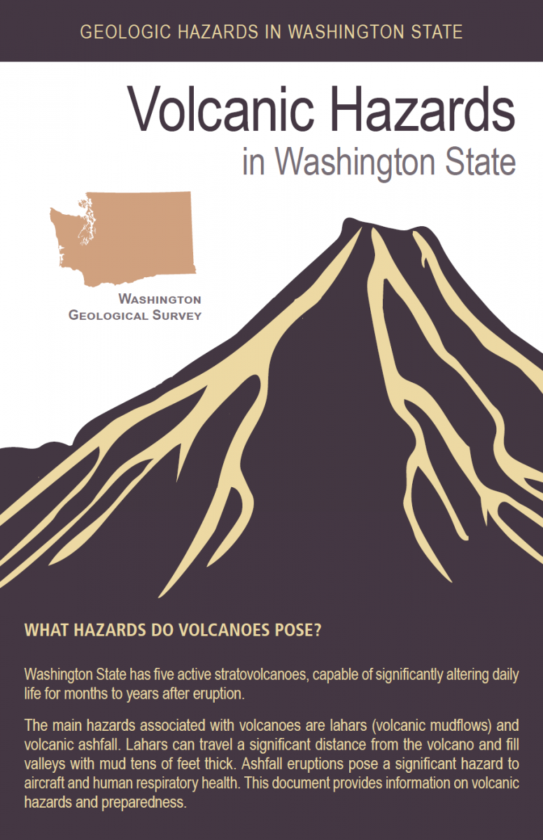
También disponible en español
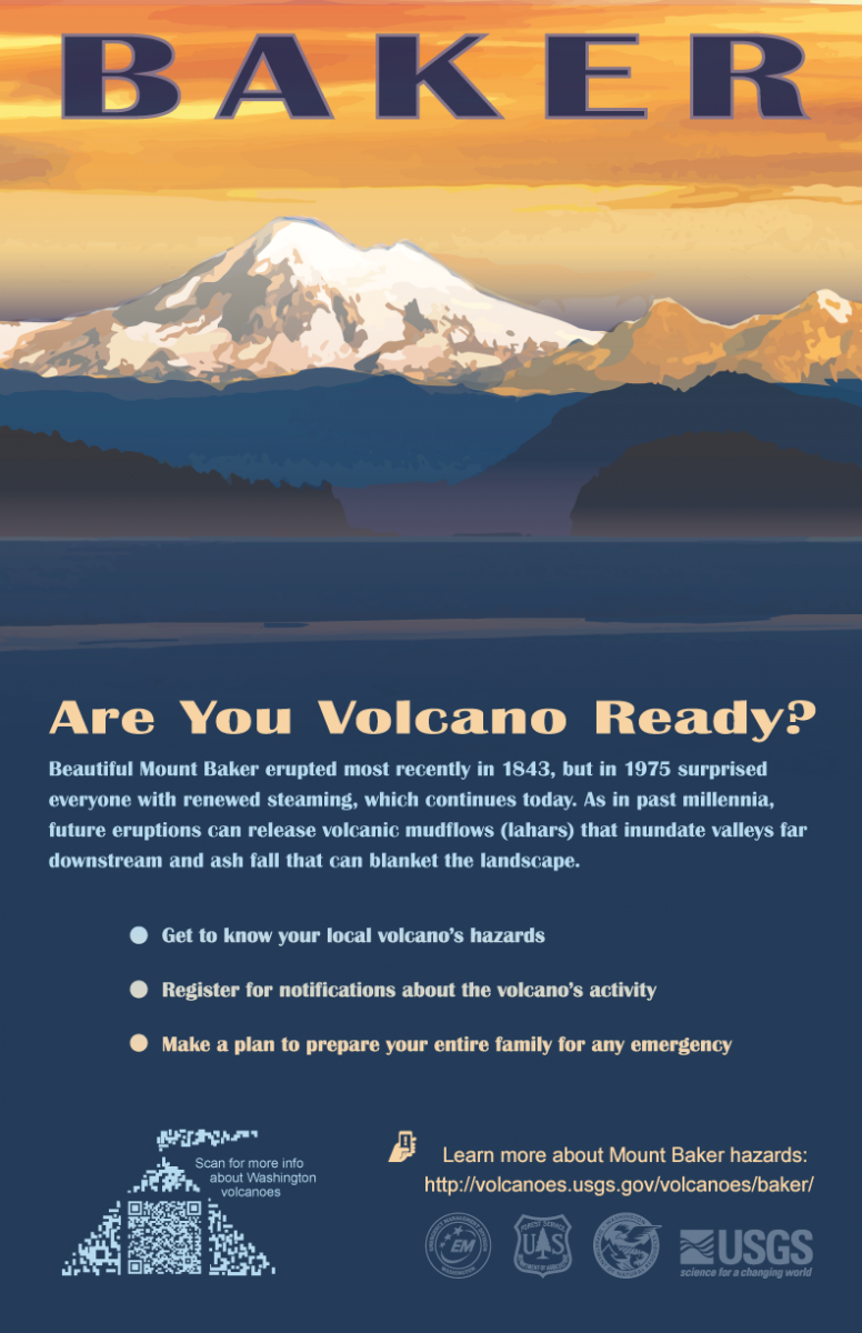
Volcano Preparedness Posters
In cooperation with the U.S. Geological Survey and several Emergency Management Departments from local counties, we have developed a series of posters to promote awareness of the hazards posed by the five active stratovolcanoes.
|
|
|
|

|
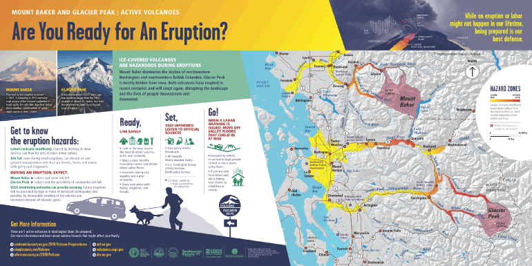
Interpretive Signs
In cooperation with the U.S. Geological Survey and several Emergency Management Departments from the state and local counties, DNR has recently developed interpretive signs that inform the public of the hazards posed by Mount Rainier, Glacier Peak, and Mount Baker. These signs are already on display in several local communities surrounding the volcanoes!
Mount Baker & Glacier Peak |
|
Mount Rainier |
|
Volcano Fun
Teacher Resources
Check out the Volcano Interactive Web Guide below, intended for middle schoolers but appropriate for all ages. This web guide will introduce you to the volcano content on the WGS website.
When you're done with the web guide, you can summarize what you learned in a creative project with the Community Hazards Plan. You can also check out the Listen Up: Monitoring Volcanoes With Sound document while you're working on the Community Hazards Plan.
|
|
|
|
Interactive
|
|
|
||
|
|
|
||
|
|
|
Videos
Drone footage of Vanuatu volcano
All about volcanoes, by SciShow Kids
